Flowtrail Siegen


- 0:50 h
- 5.79 km
- 164 m
- 160 m
- 252 m
- 415 m
- 163 m
- Start: Fischbacherberg
- Destination: Numbachtal
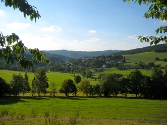
The Flowtrail Siegen is suitable for less experienced mountain bikers as well as for professionals, depending on speed. The route can be ridden in one direction from the highest point down to the valley over around 3.5 kilometres and 160 metres of altitude difference or as a circuit. Parking is available both at the starting point in the valley and near the highest point on Fischbacherberg.
The trail is operated by MTB Siegerland e.V., which provides current information on the website http://flowtrail-siegen.com. The trail is usable from April to October and only during daytime hours.
Waypoints

Good to know
Best to visit
Directions
The Flowtrail Siegen is suitable for less experienced mountain bikers as well as for professionals, depending on speed. The route can be ridden in one direction from the highest point down to the valley over around 3.5 kilometres and 160 metres of altitude difference or as a circuit. Parking is available both at the starting point in the valley and near the highest point on Fischbacherberg.
Tour information
Loop Road
Directions & Parking facilities
By car, the start and finish point can be reached from the city centre heading north/Freudenberg. From the city highway B62 at the city centre junction turn onto country road 562.
From motorway 45 coming from the north, the route leads from exit 20/Freudenberg via country road 562 towards Siegen centre. At the traffic-lighted junction Numbachstraße the starting point is located on the slope behind the Technical Relief Organisation THW and the Johanna-Ruß school.
Author
Dirk Herrmann
Organization
Touristikverband Siegen-Wittgenstein e.V.
License (master data)

Safety guidelines
The cycling route also crosses hiking trails, including the Achenbacher circular trail. On this trail, the runners have priority.
Nearby


")
Download GPX file