MTB Portal Hilchenbach (6): Across the Rothaar ridge - long distance (including Wisent World)


- 4:00 h
- 56.16 km
- 856 m
- 851 m
- 352 m
- 756 m
- 404 m
- Start: Hilchenbach marketplace
- Destination: Hilchenbach marketplace
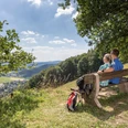
Welcome to Hilchenbach in the heart of the Rothaar Mountains!
Thanks to its prominent location on the main ridge of the Rothaar Mountains, Hilchenbach is the ideal starting point for mountain bike routes into Siegerland, Sauerland or Wittgenstein Land. Both route bikers and marathon riders will find great trails, as the region offers perfect infrastructure for beginners and ambitious cyclists alike. Whether on your own, with GPS navigation (available for loan at the Hilchenbach Tourist Information), or with a local guide – everyone can discover the most beautiful spots in the region with their bike.
Advantageously, all routes start from the same starting point, the marketplace, Hilchenbach’s parlor. After your arrival, you can confidently leave your car and enjoy your stay with your bike.

Waypoints


Good to know
Best to visit
Directions
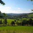
Across the main ridge of the Rothaar Mountains, you reach the high-altitude village of Jagdhaus, where restaurants and cafés welcome you. From here, you can make a short detour to reach the realm of the king of the forests, the Wisent World in Wingeshausen. In the valley, you encounter the Ederauen Cycle Path, which you follow to Röspe. From there, you get to know another Wittgenstein valley, the Zinser Bach valley.
Catering options: Hilchenbach marketplace, Jagdhaus
Equipment
Directions & Parking facilities
Arrival by car
Coming from Gießen (A 45): At the Siegen exit, first turn onto B 62 towards Kreuztal/Siegen, then onto B 54
follow B 54 towards Kreuztal/Netphen/Siegen. Follow the route until the Kreuztal/Stadtmitte/Olpe/Hilchenbach exit
(B 508). Follow B 508 to Hilchenbach.
Coming from Dortmund (A 45): At the Olpe-Süd interchange, turn onto A 4 towards Wenden/Kreuztal.
Follow the route. At the Kreuztal/Stadtmitte/Olpe/Hilchenbach exit, turn onto B 508. Follow B 508 to
Hilchenbach.
Coming from Cologne (A 4): At the Olpe-Süd interchange, continue on A 4 towards Wenden/Kreuztal. At the exit
Kreuztal/Stadtmitte/Olpe/Hilchenbach turn onto B 508. Follow B 508 to Hilchenbach.
In Hilchenbach near the marketplace:
- In der Herrenwiese (opposite fire station, In der Herrenwiese 10)
- Rothenberger Str. (opposite house number 10)
Train
Long-distance / Regional traffic
Essen – Hagen – Siegen (RE 16 "Ruhr-Sieg-Express", hourly)
Hagen – Finnentrop – Siegen (RB 91 "Ruhr-Sieg-Bahn", every two hours)
Cologne – Siegen (RE 9 "Rhein-Sieg-Express", hourly)
Frankfurt – Siegen (RE 40, every two hours)
Local traffic
Siegen – Kreuztal – Hilchenbach (RB 93 "Rothaarbahn")
Schedules: weekdays hourly, Saturday afternoon from 6:00 p.m. and Sundays every two hours;
Connections from Bad Laasphe, Biedenkopf and Marburg in Erndtebrück with the "Upper Lahn Valley Railway" (RB 94) every two hours
More information: www.bahn.de
Bus
Westfalen-Süd Transport Association on the routes
- Siegen – Kreuztal – Hilchenbach – Helberhausen (R 11)
- Netphen – Dreis-Tiefenbach – Eckmannshausen – Herzhausen – Hilchenbach (R 20)
- Lennestadt-Altenhundem – Hilchenbach (R 92)
- Dahlbruch – Müsen (L 170)
- Ruckersfeld – Oechelhausen – Vormwald – Grund – Allenbach – Hilchenbach (T 171)
- Hilchenbach – Settlement – Vormwald – Helberhausen (T 172)
BRS Ruhr-Sieg Bus GmbH on the routes:
Siegen - Hilchenbach - Erndtebrück - Bad Berleburg (60)
Lennestadt-Altenhundem - Hilchenbach - Erndtebrück (76)
Hilchenbach - Bad Laasphe - Biedenkopf (975)
Additional information
Tourist Information / Room Reservation
Markt 13, Town Hall
57271 Hilchenbach
Tel.: 02733/288-133
Fax: 02733/288-288
E-mail: touristinfo@hilchenbach.de
Website: www.hilchenbachtourist.de
Opening hours
Monday - Wednesday: 7:00 - 16:30
Thursday: 7:00 - 18:00
Friday: 7:00 - 12:30
Author
Susanne Träger
Organization
Stadt Hilchenbach
License (master data)

Author´s Tip / Recommendation of the author
Be sure to plan enough time for a visit to the Wisent World in Jagdhaus.
(From Jagdhaus, follow the paved road approximately 3 km towards Wingeshausen.)
Safety guidelines
Check your equipment, assess your abilities correctly. Bad weather or a breakdown can significantly extend the route. Hilchenbach is located in the forest-richest district of Germany. Due to active forestry, paths may change.
Leave your route plan at home or at the accommodation before departure.
Observing the DIMB Trailrules (German Initiative Mountainbike e.V.) helps to protect nature and improve coexistence in the forest and on the mountain. Please note:
1. Ride only on paths
2. Leave no traces
3. Keep your mountain bike under control
4. Respect other nature users
5. Be considerate to animals
6. Plan ahead
FAIR ON TRAILS! Enjoy and preserve nature – together!
Note the State Forest Act for North Rhine-Westphalia, which includes important regulations for entering the forest.
Map
The route is not marked on the maps. The maps can serve for orientation and alternative planning (all relevant maps for the MTB portal).
- Hiking map Hilchenbach (1:25,000), available at the Hilchenbach Tourist Information (www.hilchenbachtourist.de)
- Hiking map Kreuztal (1:25,000), available at the Hilchenbach Tourist Information (www.hilchenbachtourist.de)
- Hiking map Netphen (1:25,000), available at the local bookstore (e.g. www.buecherbuyeva.de, Rothenberger Str. 23, Hilchenbach)
- Hiking map Lennestadt/Kirchhundem (1:25,000), available at the Hilchenbach Tourist Information (www.hilchenbachtourist.de)
- Hiking map Wittgenstein (1:50,000), available at the local bookstore (e.g. www.buecherbuyeva.de, Rothenberger Str. 23, Hilchenbach)
- Hiking map Rothaarsteig (1:50,000), available at the Hilchenbach Tourist Information (www.hilchenbachtourist.de)
- Hiking map Wilnsdorf (1:25,000), available at the local bookstore (e.g. www.buecherbuyeva.de, Rothenberger Str. 23, Hilchenbach)
- Hiking map Burbach (1:25,000), available at the local bookstore (e.g. www.buecherbuyeva.de, Rothenberger Str. 23, Hilchenbach)
Nearby


