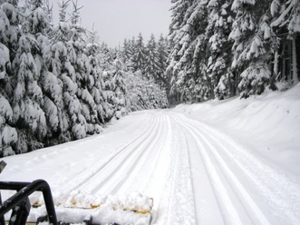
Haincher Höhe cross-country trail 14 km


- 3:27 h
- 13.66 km
- 173 m
- 173 m
- 548 m
- 678 m
- 130 m
- Start: Haincher Höhe hiking car park
- Destination: Haincher Höhe hiking car park
Via the Haincher Höhe and the Rothaarsteig the route leads towards Kaffeebuche, Herrenberg and Jagdberg (675 m above sea level). This is not only the highest mountain of Netphen but also the highest point of the Hessian Lahn-Dill district. The route continues towards Heiligenborn, then towards Lahnhof, back to Jagdberg and returns to the starting point at the Haincher Höhe hiking car park.
An information board at the starting point gives you an overview of the groomed trails. The circuit is continuously marked with kilometre signs. Further entry points to this trail: Heiligenborn cemetery parking, Schulplatz parking on Eisenstraße
Further information is available on the website of the Ski-Club Oberes Johannland e.V.
Good to know
Best to visit
Directions
Starting from the Haincher Höhe hiking car park, take the left path at the fork. This leads us steadily uphill in gentle waves. After about 1.5 km we reach the Rothaarsteig. We pass the Kaffeebuche rest stop, from which we can enjoy a beautiful view of Johannland. After 800 m we encounter the Rittershäuser Wetterstein. After 1.2 km turn right. At the end of the path always keep left. In front of us now lies a steep and short ascent to the Jagdberg.
At the top, choose the right path at the junction towards Heiligenborn. At the height of the Heiligenborn cemetery, turn left. After 1.2 km take the left path again. After 800 m you reach the junction on the Jagdberg again and follow the Rothaarsteig towards Hainchen-Kaffeebuche. The next 1.5 km is a rapid descent. Arriving at Rittershäuser Wetterstein, keep right and after 1 km reach the Kaffeebuche. From here, follow the known route back to the starting point.
Tour information
Loop Road
Equipment
Directions & Parking facilities
The district Hainchen is located on the L729 and is connected to the A45 via Wilnsdorf. From the A4 and from the Olpe-Süd motorway interchange there is a connection via the B54 to Siegen. From there follow the B62 to Dreis-Tiefenbach and further to Netphen. In Netphen, take the L729 bypass road to Deuz, then via Salchendorf, Helgersdorf, Werthenbach and Hainchen.
Follow the L729 through Hainchen towards Dietzhölztal. The Haincher Höhe hiking car park is located about 2 km behind the exit of Hainchen in a sharp right-hand bend on the left side.
Additional information
Further information is available from the Ski-Club Oberes Johannland e.V.
Author
Kirsten Müller
Organization
Touristikverband Siegen-Wittgenstein e.V.
License (master data)

Author´s Tip / Recommendation of the author
Safety guidelines
- Everyone should behave on the cross-country trail so that they neither endanger nor obstruct others.
- The direction of travel should be observed. The tips of the trail signs point in the direction of travel. In double trails, the right lane should always be used.
- Pedestrians are requested not to enter the trail but to choose other routes.
- Stay on the marked trail to avoid disturbing the wildlife.
- Take your litter home with you.
- Keep the trails clear. Those who stop should step out of the trail.
Nearby


Download GPX file