Haincher Höhe trail, 7 km


- 1:38 h
- 6.66 km
- 78 m
- 77 m
- 548 m
- 614 m
- 66 m
- Start: Haincher Höhe hikers’ car park
- Destination: Haincher Höhe hikers’ car park
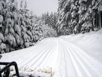
This tour takes you from the Haincher Höhe hill along the Rothaarsteig hiking trail to the “Rittershäuser Wetterstein”, and back to the starting point. An information panel at the starting point offers an overview of the prepared cross-country trails. The circular route is marked throughout with kilometre signs. If you have any questions about the trail or snow levels, contact the snow hotline on +49 2737 93153.

Good to know
Best to visit
Directions
Tour information
Loop Road
Equipment
Directions & Parking facilities
Follow the L 729 through Hainchen towards Dietzhölztal. The Haincher Höhe hikers’ car park is about 2 km behind the entrance to Hainchen, at a sharp right bend in the road on the left-hand side.
Additional information
Author
Kirsten Müller
Organization
Touristikverband Siegen-Wittgenstein e.V.
License (master data)

Safety guidelines
- Everyone should behave on the trails in such a way that they neither endanger nor hinder others.
- The correct skiing direction should be observed. The tops of the trail signs indicate the correct skiing direction. Where there are double trails, the right-hand track should always be used.
- Walkers are requested not to step on the trails, but to use other routes.
- Stay on the marked trail to avoid disturbing the wildlife.
- Take your rubbish home with you.
- Keep the trails free. Anyone who needs to stop should step out of the track.
Nearby


Download GPX file