MTB portal Hilchenbach (1): Seven Summits Hilchenbach
")

")
- 3:45 h
- 32.51 km
- 551 m
- 551 m
- 345 m
- 678 m
- 333 m
- Start: Hilchenbach marketplace
- Destination: Hilchenbach marketplace
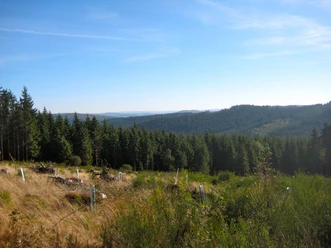
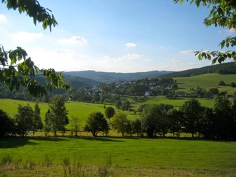
Welcome to Hilchenbach in the midst of the Rothaar Mountains!
Thanks to its exposed location on the main ridge of the Rothaar Mountains, Hilchenbach is the ideal starting point for mountain bike routes into Siegerland, Sauerland, or Wittgensteiner Land. Both route bikers and marathon riders will find great tracks, as the region offers perfect infrastructure for beginners and ambitious riders. Whether independently, with GPS navigation (available for loan at the Tourist Information Hilchenbach), or with a local guide – everyone can discover the most beautiful corners of the region with their bike.
Advantageously, all routes start from the same starting point, the marketplace, Hilchenbach’s living room. After your arrival, you can safely leave your car and enjoy your stay with your bike.

Waypoints


Good to know
Best to visit
Directions
The highest peaks around Hilchenbach
Riemen, Klarstein, Gillerberg, Pfaffenhain, Buchenhain, Drei Buchen, and Hüttenberg are called the "7 Summits" – Hilchenbach’s highest mountains – which you will pass on this route. The route takes you from the widely visible wind turbines over the Oberndorfer Höhe to the highest mountain in Siegerland, the Riemen. Then you climb the mountains around Hilchenbach five more times in an eastern arc until you return to Hilchenbach marketplace.
Places to stop: Hilchenbach marketplace, Ginsburg, Ginsberger Heide
Tour information
Cultural Interesting
Loop Road
Stop at an Inn
Summit
Equipment
Directions & Parking facilities
Arrival by car
Coming from Gießen (A 45): At the Siegen exit, first turn onto the B 62 towards Kreuztal/Siegen, then onto the B 54
merge towards Kreuztal/Netphen/Siegen. Follow the route until the Kreuztal/Stadtmitte/Olpe/Hilchenbach exit
(B 508). Follow the B 508 to Hilchenbach.
Coming from Dortmund (A 45): At the Olpe-Süd motorway junction, turn onto the A 4 towards Wenden/Kreuztal.
Follow the route. At the Kreuztal/Stadtmitte/Olpe/Hilchenbach exit, turn onto the B 508. Follow the B 508 to
Hilchenbach.
Coming from Cologne (A 4): At the Olpe-Süd motorway junction, continue on the A 4 towards Wenden/Kreuztal. At the
Kreuztal/Stadtmitte/Olpe/Hilchenbach exit, turn onto the B 508. Follow the B 508 to Hilchenbach.
In Hilchenbach near the marketplace:
- In der Herrenwiese (opposite fire station, In der Herrenwiese 10)
- Rothenberger Str. (opposite house number 10)
Train
Long-distance/Regional traffic
Essen – Hagen – Siegen (RE 16 “Ruhr-Sieg-Express”, hourly)
Hagen – Finnentrop – Siegen (RB 91 “Ruhr-Sieg-Bahn”, every two hours)
Cologne – Siegen (RE 9 “Rhein-Sieg-Express”, hourly)
Frankfurt – Siegen (RE 40, every two hours)
Local traffic
Siegen – Kreuztal – Hilchenbach (RB 93 “Rothaarbahn”)
Timetable: on weekdays hourly, Saturday afternoons from 6:00 pm and Sundays every two hours;
Connection options from Bad Laasphe, Biedenkopf, and Marburg in Erndtebrück with the "Upper Lahn Valley Railway" (RB 94) every two hours
More information: www.bahn.de
Bus
Westfalen-Süd transport association on the routes
- Siegen – Kreuztal – Hilchenbach – Helberhausen (R 11)
- Netphen – Dreis-Tiefenbach – Eckmannshausen – Herzhausen – Hilchenbach (R 20)
- Lennestadt-Altenhundem – Hilchenbach (R 92)
- Dahlbruch – Müsen (L 170)
- Ruckersfeld – Oechelhausen – Vormwald – Grund – Allenbach – Hilchenbach (T 171)
- Hilchenbach – Siedlung – Vormwald – Helberhausen (T 172)
BRS Busverkehr Ruhr-Sieg GmbH on the routes:
Siegen - Hilchenbach - Erndtebrück - Bad Berleburg (60)
Lennestadt-Altenhundem - Hilchenbach - Erndtebrück (76)
Hilchenbach - Bad Laasphe - Biedenkopf (975)
Additional information
Tourist Information / Accommodation Service
Markt 13, Town Hall
57271 Hilchenbach
Phone: 02733/288-133
Fax: 02733/288-288
E-mail: touristinfo@hilchenbach.de
Website: www.hilchenbachtourist.de
General opening hours
Monday, Tuesday, Thursday: 7:30 am – 4:30 pm
Wednesday and Friday: 7:30 am – 12:30 pm
Literature
Author
Susanne Träger
Organization
Stadt Hilchenbach
License (master data)

Author´s Tip / Recommendation of the author
Safety guidelines
Check your equipment, assess your skills correctly. Bad weather or a breakdown can significantly extend the route. Hilchenbach is located in the most densely forested district in Germany. Due to active forestry, there may be changes to paths.
Before departure, leave your route plan at home or at the guest establishment.
Following the DIMB Trailrules (German Initiative Mountainbike e.V.) helps to protect nature and improve coexistence in the forest and on the mountain. Please note:
1. Ride only on paths
2. Leave no trace
3. Keep your mountain bike under control
4. Respect other nature users
5. Consider animals
6. Plan ahead
FAIR ON TRAILS! Enjoy and preserve nature – together!
The state forest law for the state of North Rhine-Westphalia, which contains important regulations for entering the forest, must be observed.
Map
The route is not marked on the maps. The maps can serve as orientation and for alternative planning (all relevant maps for the MTB portal).
- Hiking map Hilchenbach (1:25,000), available at the Tourist Information Hilchenbach (www.hilchenbachtourist.de)
- Hiking map Kreuztal (1:25,000), available at the Tourist Information Hilchenbach (www.hilchenbachtourist.de)
- Hiking map Netphen (1:25,000), available at local bookstores (e.g., www.buecherbuyeva.de, Rothenberger Str. 23, Hilchenbach)
- Hiking map Lennestadt/Kirchhundem (1:25,000), available at the Tourist Information Hilchenbach (www.hilchenbachtourist.de)
- Hiking map Wittgenstein (1:50,000), available at local bookstores (e.g., www.buecherbuyeva.de, Rothenberger Str. 23, Hilchenbach)
- Hiking map Rothaarsteig (1:50,000), available at the Tourist Information Hilchenbach (www.hilchenbachtourist.de)
- Hiking map Wilnsdorf (1:25,000), available at local bookstores (e.g., www.buecherbuyeva.de, Rothenberger Str. 23, Hilchenbach)
- Hiking map Burbach (1:25,000), available at local bookstores (e.g., www.buecherbuyeva.de, Rothenberger Str. 23, Hilchenbach)
Nearby


Download GPX file