Rothaarsteig from Wilgersdorf to Dillenburg


- 6:10 h
- 22.35 km
- 475 m
- 645 m
- 223 m
- 510 m
- 287 m
- Start: Wilnsdorf-Wilgersdorf
- Destination: Dillenburg
This stage initially leads back via the access path to the junction "Hubertusbuche." From here you follow the Rothaarsteig southwards and soon reach the 300 m long Hauberg path, which provides information about the Hauberg forestry practice. This special form of land use, a combination of agriculture and wood production, arose in the course of iron smelting. After a few meters at the crossroads "Kalteiche," the Rothaarsteig splits. The main path leads directly to Dillenburg. The Westerwald variant of the Rothaarsteig also leads to Dillenburg but via the Fuchskaute in the High Westerwald. At this fork, you decide for the direct path to Dillenburg.
Here, the trail slowly says goodbye to the Rothaar Mountains and turns to the Lahn-Dill Highlands. The finale leads the Rothaarsteig to Dillenburg, down to 230 meters into the former residence of Wilhelm of Orange, the founder of the Netherlands.
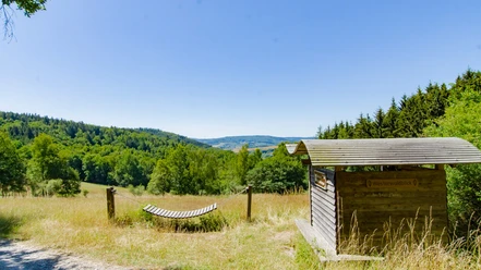
On the way, you will first encounter the natural monument Lucaseiche, with its 27.5 meters height and a trunk circumference of 3.85 meters, an impressive sight. Past the idyllic Forester's Lodge Steinbach, the Rothaarsteig leads into the Dill valley towards Rodenbach. The Westerwaldblick viewpoint motivates a last ascent over the Struth. Over the Galgenberg (302 m), it then goes into the Oranien town Dillenburg.
Those who still need to catch the last train or do not want to wait any longer for a reward in the form of a refreshment can take a yellow-black marked access path directly into the city center of Dillenburg here. If you want to complete the entire route, you continue to the Bismarck Temple to enjoy the magnificent view of the entire town with the Wilhelm Tower facing it. Along narrow paths, it goes down to the old town of Dillenburg. Ultimately, the Rothaarsteig leads you through the courtyard garden to the train station, the endpoint of the route.
Waypoints


Good to know
Best to visit
Directions
Kalteiche - Lucaseiche - Dill Valley - Dietzhölztal - Galgenberg - Dillenburg
Tour information
Cultural Interesting
Familiy-Friendly
Labelling
Possibility of Accommodation
Premium Trail "Wanderbares Deutschland"
Stop at an Inn
Tour with Dog
Equipment
The Rothaarsteig leads over numerous natural paths away from agricultural and forestry roads. Therefore, weatherproof clothing and sturdy footwear are a must for every hike. We want you not only to stay "dry" but also to experience the "path of the senses" with "good" feet.
In our small hiking shop at www.rothaarsteig.de/shop you will also find a selection of Rothaarsteig items to prepare for your route or as souvenirs. We also gladly recommend the durable and quality outdoor equipment of our long-standing partner, the outdoor outfitter Tatonka.
Hiking backpack
With a suitable hiking backpack, your route on the Rothaarsteig will be twice as much fun! Hiking backpacks offer very pleasant carrying properties through a ventilated carrying system, which ensures that sweat can evaporate immediately. They can be fixed with a belly or hip belt and thus sit firmly on your back during every movement. In addition, they are equipped with a practical holder for hiking poles and often offer a compartment with a hose outlet for a hydration bladder so that fluid supply is always secured.
First aid kit
To fully enjoy your hiking tour on the Rothaarsteig safely, a first aid kit should definitely be in your backpack. After all, nothing is more annoying than a blister on your foot or small injuries that cannot be treated cleanly immediately. The first aid kits from Tatonka are filled with all important materials for first aid treatment of injuries and also contain an "outdoor cheat sheet" with a brief and clear guideline for proper behavior in emergencies in the open nature. Here you will find the first aid kits from Tatonka!
Food and drinks
On some stages, especially between Lahnhof and Dillenburg, there are unfortunately no opportunities to stop for refreshments along the way. Especially here, remember to pack food and drinks. In summer, sufficient fluid intake is particularly important.
Directions & Parking facilities
Wilgersdorf:
In Wilgersdorf, you can park for free at the Wachholderheide hiking parking lot on the yellow-marked Rothaarsteig access path.
Dillenburg
Free parking is available at the stadium in Dillenburg. Enter "Am Sportzentrum" in your navigation system.
Wilgersdorf is served by various bus lines. The nearest train station is located in Rudersdorf, where trains travel towards Siegen and Dillenburg.
Dillenburg is also connected by various train and bus routes. From Dillenburg station, lines run towards Siegen and Betzdorf, as well as long-distance traffic towards Gießen/Frankfurt and Münster.
Further information can be found at www.bahn.de.
Literature
Further information about the Rothaarsteig is available at www.rothaarsteig.de or by phone at the free service hotline +49 2974 / 499 4163. We are happy to advise you personally on your route planning.
To prepare for your hike, we would be happy to send you our free information package. At www.rothaarsteig.de/prospekte you can easily choose which information you need. A good companion for every route is our brochure "Rothaarsteig Guide" with hosts along the trail and other useful information.
The Rothaarsteig recommends:
- Hikeline hiking guide: Long-distance trail Rothaarsteig - From Brilon in Sauerland over the ridge of the Rothaar Mountains to Dillenburg
- Conrad Stein Publisher: Hiking guide Rothaarsteig – Long-distance trail. Rothaarsteig from Brilon to Dillenburg by Amrei Risse
- Rother mountain publisher: Rother hiking guide Rothaarsteig. With Sauerland Höhenflug and Sauerland forest route by Matthias Schopp
Contact person
Author
Harald Knoche
Organization
Rothaarsteigverein e. V.
License (master data)
Author´s Tip / Recommendation of the author
- Kalteiche
- Lucaseiche
- Forester's Lodge Steinbach
- Bismarck Temple Dillenburg
- Wilhelm Tower Dillenburg
- Courtyard Garden Dillenburg
Guest businesses:
Safety guidelines
Information about the emergency signs on the Rothaarsteig
Hiking trails mostly run away from towns and settlements, and everyone who hikes has certainly wondered about what to do in case of an emergency. How can I be found here? Where am I actually? Can the rescue service reach me?
In an emergency, speed is crucial! Therefore, the Rothaarsteig is continuously equipped with so-called rescue signs. On the green-white plaques attached to the posts of the signposts, there is a number that you must provide when making an emergency call. This way, the rescue forces know exactly where you are, and valuable time can be saved.
Note about the increased risk of forest fire
Please keep in mind that due to dryness, there is currently an increased forest fire risk! Therefore, please observe the following instructions:
- Adhere to the legal smoking ban in the forest - it applies in spring, summer, and autumn, specifically from March 1 to October 31.
- Observe the ban on open fires in the forest and within 100 meters of the forest.
- Take glass out of the forest - the burning glass effect can cause forest fires.
If it is (too) late:
- Extinguish small starting fires if it is safely possible for you. Check the spot carefully if necessary.
- Report fires via "112".
- Leave the danger area via the shortest route.
The forest thanks you!
Map
Rothaarsteig hiking map at scale 1:50,000
- Divided into two sheets (North sheet / South sheet)
- 10th edition - current route guidance
- With marked shelters, viewpoints, bus stops, parking lots, and more.
- Free shipping in the Rothaarsteig hiking shop
Nearby


