Rothaarsteig Track Dill Mountain Route


- 4:20 h
- 15.89 km
- 291 m
- 291 m
- 327 m
- 579 m
- 252 m
- Start: Mühlenhof 1 - Haiger-Offdilln
- Destination: Mühlenhof 1 - Haiger-Offdilln
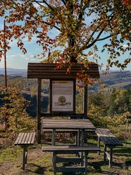
Idyllic Dill Valley and scenic Rothaar Ridge – you can discover both on the Rothaarsteig track "Dill Mountain Route". After starting at the edge of Offdilln, the path leads through the historic Hauberg Offdilln, providing insights into this ancient form of forest management. The picturesque spring of the "Bocksborn" invites you to take a break. Once reached the Rothaarsteig, grand views open up to the Lahn-Dill mountainous region and the Siegerland. Evening ambiance at the viewing platform "Nose in the Wind" on the Tiefenrother Höhe is truly an experience! The Hauberg Path nearby again offers insights into forest users’ activities. On request, the rangers of the state enterprise forestry and wood NRW offer guided tours here. Passing the approximately 220-year-old "Lucaseiche" near the "Forsthaus Steinbach", the way goes past Dillbrecht back to Offdilln.
Waypoints


Good to know
Best to visit
Directions
Offdilln - Historic Hauber Offdilln - Bockshorn Spring - Gernsbacher Höhe - Viewing Platform "Nose in the Wind" - Tiefenrother Höhe - Hauberg Path - Kalteiche - Lucaseiche - Dillbrecht - Offdilln
Equipment
The Rothaarsteig runs over numerous natural paths away from agricultural and forestry roads. Therefore, weatherproof clothing and sturdy footwear are a must for every hike. We want you not only to experience the "Path of the Senses" "dry" but also with "good" feet.
In our small hiking shop at www.rothaarsteig.de/shop you will also find a selection of Rothaarsteig articles to prepare for your route or as souvenirs. We also gladly recommend the durable and high-quality outdoor equipment from our long-term partner, the outdoor outfitter Tatonka.
Hiking backpack
With a suitable hiking backpack your tour on the Rothaarsteig is twice as much fun! Hiking backpacks offer very comfortable wearing properties through a ventilated carrying system that ensures sweat evaporates immediately. They can be fixed with a belly or hip belt and thus sit firmly on the back during every movement. Additionally, they are equipped with a practical holder for hiking poles and often have a compartment with a hose outlet for a hydration bladder to ensure fluid supply at all times.
Rainwear
If changeable weather is forecast for your tour on the Rothaarsteig, remember to pack a light rain jacket or rain poncho. They take up almost no space in your backpack and also protect against unpleasant wind. Also practical are gaiters that protect the trouser legs from dirt and moisture. At our partner, the outdoor outfitter Tatonka, you can find high-quality, breathable rain jackets with minimal pack size, light rain capes, and gaiters for the trouser legs to keep them protected from dirt and moisture.
Here you can find Tatonka rain jackets for women
Here you can find Tatonka rain jackets for men
First aid kit
To fully enjoy your hiking tour on the Rothaarsteig, a first aid kit belongs in your backpack as a safety measure. After all, nothing is more annoying than blisters on the feet or small injuries that cannot be properly cared for immediately. The first aid kits from Tatonka are filled with all important materials for initial treatment of injuries and contain additionally an "outdoor cheat sheet" with concise and clear guidelines for correct behavior in emergencies in the open nature.
Here you can find the first aid kits from Tatonka!
Food and drinks
On some stages, especially between Lahnhof and Dillenburg, unfortunately there are no dining options along the way. Remember especially here to pack food and drinks. Especially in summer, sufficient fluids are important.
Directions & Parking facilities
In Offdilln there are free hiking parking spaces available.
In Haiger-Dillbrecht there is a train station directly on the route. You can of course also start your hike there. In this case, we recommend hiking from Dillbrecht towards Offdilln.
Further information can be found at www.bahn.de.
Additional information
Further information about the Rothaarsteig is available at www.rothaarsteig.de or by phone via the free service hotline at +49 2974 / 499 4163. Here we will gladly advise you personally on your route planning.
Literature
To prepare for your hike, we are happy to send you our free information package. At www.rothaarsteig.de/prospekte you can easily choose which information you need. A good companion for every route is our brochure "Rothaarsteig Guide" with hosts along the trail and other useful information.
Author
Katharina Schwake-Drucks
Organization
Touristikverband Siegen-Wittgenstein e.V.
License (master data)

Author´s Tip / Recommendation of the author
- Viewing platform "Nose in the Wind" on the Tiefenrother Höhe
- Hauberg Path with insights into forest management
- Over 220 years old natural monument Lucaseiche
Safety guidelines
Information about the rescue boards on the Rothaarsteig
Hiking trails mostly run away from towns and settlements, and those who hike have surely thought about what would happen in an emergency. How can I be found here? Where exactly am I? Can the rescue service reach me?
In an emergency, things must happen fast! Therefore, the Rothaarsteig is continuously equipped with so-called rescue signs. On the green-white plaques attached to the signposts, there is a number you must give when calling emergency services. This way, rescuers know exactly where you are, and valuable time can be saved.
Note on increased forest fire risk
Please be aware that due to dryness there is currently an increased forest fire risk! Please observe the following:
- Observe the legal smoking ban in the forest - valid in spring, summer and autumn, specifically from March 1 to October 31.
- Observe the ban on open fires in the forest and within 100 meters of the forest.
- Take glass out of the forest - the burning glass effect can cause forest fires.
If it’s (too) late:
- Extinguish small fires if it is safe to do so. Check the area carefully if needed.
- Report fires via "112".
- Leave the danger area via the shortest way.
The forest thanks you!
Map
In our brochure „Rothaarsteig Tracks - All Circular Hikes at a Glance“ you will find map sections, short explanations, and a map for the Breitscheider Cave Tour for all 14 circular hikes. At www.rothaarsteig.de/prospekte you can conveniently and free of charge order the booklet to your home or view it online as a PDF or flip catalog.
We also recommend the hiking pass for the Rothaarsteig tracks. Those who have hiked 8 of the total 14 tracks receive a hiking certificate as well as a Rothaarsteig pin and participate in our annual raffle. You can also order the hiking pass free of charge at www.rothaarsteig.de/prospekte or download it directly online.
The original Rothaarsteig hiking map at a scale of 1:50000 on waterproof paper, with current route guidance and useful markings such as shelters, parking lots, bus stops, and more, can be conveniently ordered free of shipping charges for 11.00 Euro at www.rothaarsteig.de/wanderkarte.
Nearby


