F4 - Hohenhain-Wildenburger Land


- 2:50 h
- 9.85 km
- 163 m
- 163 m
- 308 m
- 425 m
- 117 m
- Start: Hiking parking lot Hohenhain "Schlagsberg"
- Destination: Hiking parking lot Hohenhain "Schlagsberg"
The hiking trail is partly very rugged and at times also wet on some sections. Therefore, good footwear and appropriate clothing are recommended. The trail corresponds to the topographical conditions of the Siegerland region.

Waypoints
Good to know
Best to visit
Directions
We start counterclockwise at the hiking parking lot "Schlagsberg" at the entrance of Hohenhain coming from Freudenberg. From here, we follow the path sign F4 to the village entrance and turn right onto "Alter Schanzenweg". We continue into the village center.
On Römerhagener Street, we see the first sight of the hike: the half-timbered gable of the second oldest house in Hohenhain, built in 1795, which is protected as a monument.
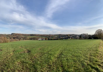
We continue on "Zum Bohnengarten" street to the Hohenhain boundary. Before the forest, we turn left onto the field and forest path. Here, there is a beautiful view of Hohenhain.
At the end of this small hollow way, we turn half-left onto the wide forest path. Shortly after, we leave North Rhine-Westphalia and cross the state border into Rhineland-Palatinate.
This path meanders along the mountain. Along the way, we have magnificent views of the Wildenburg and further into the Bergisches Land.
Shortly before the end of the path, there is a high seat; about 50 m earlier a small path leads downhill through the spruce forest. Once at the bottom, we cross the Grünebach. Then we keep left. At the top on the right side, we can make out the farm "Heiligenborn".
Further on, we see a small ravine, which offers a bizarre view especially in winter with ice and snow. A few meters further on the left is a high rock edge called "Die Kanzel". According to legend, this place was a cult and sacrificial site in the early Middle Ages.
The path leads us to the next fork. We hike up the right path. At the top, on the right side, we see something hidden in the forest: an old fortification from the time of the Brüder- and Hille-trail. The path continues to the next crossroads. Here we go left towards Wildenburg station, where there is the possibility to take a break at "Maulwurf".
From here, it continues straight uphill over the main road to the Wildenburg. Once down in the valley and back on the main road, we go right to the exit of Wildenburg village.
Shortly after the bridge, we turn sharply left onto a small forest path. We follow this path to a crossroads. Then we continue hiking, after a short left curve steeply uphill.
After crossing the ridge and arriving back in the valley, we go up on the right side again. After about 200 m, we turn left onto the forest path. We follow this path to the bike path. (Those who dare can also hike down through the valley; however, this part of the route is partly very wet.) At the top on the path, we go left to the bike path. The beauty of nature compensates for the hardships. Those with enough time can admire countless plants and animals.
We continue towards Hohenhain, passing the old station. After nearly 100 m, we reach the "English Garden". Depending on opening hours, there is the possibility to quench your thirst or have a small snack after the hike.
The hike continues uphill towards the destination. Once in the village, there is the possibility to end a wonderful hike at the Café Restaurant "Alte Schanze".
Tour information
Cultural Interesting
Loop Road
Stop at an Inn
Equipment
The hiking trail is partly very rugged and at times also wet on some sections. Therefore, good footwear and appropriate clothing are recommended.
Directions & Parking facilities
From Siegen Hbf/ZOB with lines R38 / R37 to Freudenberg ZOB, Freudenberg-Hohenhain line L151 Hohenhain village; 200 m back to start and finish.
From Olpe or Wenden with line R42 to Hohenhain stop; 200 m to start and finish.
From Morsbach with line 276A to Hohenhain stop; 200 m to start and finish.
Author
Pauline Coroly
Organization
Stadt Freudenberg
License (master data)

Author´s Tip / Recommendation of the author
At the beginning or end of the hike, the Café Restaurant "Alte Schanze" near the hiking parking lot is recommended.
Nearby


Download GPX file