


- 2:30 h
- 8.58 km
- 220 m
- 220 m
- 390 m
- 540 m
- 150 m
- Start: The starting point is the hiking signboard at the Volksbank on Sieg-Lahn-Straße
- Destination: The destination point is the hiking signboard at the Volksbank on Sieg-Lahn-Straße
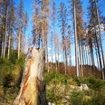
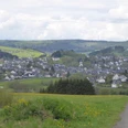
From the hiking signboard at the Volksbank, the hiking trail turns right at the intersection, then after about 50 m turns right again into the street "Auf der Ley." Crossing the Feudinge bridge and the railway crossing, we continue along the street "Am Hornberg" to the town outskirts. The path then leads uphill along the slope of the Feudinge valley with wide views over the adjacent villages of Rüppershausen, Oberndorf with its church, and Rückershausen with ski facilities. Before entering the forest after a path junction, a bench invites you to take a short rest. After that, we continue, always following the F5 trail marker, along the Trauberg above the Laxbach flowing in the valley, through the spruce forest to Holzhausen. After leaving the forest here, turn right at the second fork. After a short distance, past an open stable of a farm, turn right again. On a service road, we leave the small village of Holzhausen. At the next fork, keep to the right and walk along the forest edge into the wide Welschebach valley. After the open path on the slope, we enter the forest again and go slightly uphill on the right. Then the hiking trail leads above Bermershausen into a small side valley. Further along the route, we overcome a short climb until we pass a hunting lodge to the left beneath the path on a forest road. Following the path further, we then reach Scharfenstein, which in earlier centuries was considered a meeting place for demons and other sinister figures. There is also said to have been a tunnel leading to the castle in Bad Laasphe. The impressive natural monument and the great view into the Lahn valley, which can also be enjoyed from a bench, compensate for the strenuous ascent. Afterwards, we continue along the path that leads downhill back towards Feudingen. After the descent, we reach the starting point of the hike again via the "Am Vogelsang" path and the "Sieg-Lahn-Str."

Good to know
Best to visit
Directions
From the hiking signboard at the Volksbank, the hiking trail turns right at the intersection, then after about 50 m turns right again into the street "Auf der Ley." Crossing the Feudinge bridge and the railway crossing, we continue along the street "Am Hornberg" to the town outskirts. The path then leads uphill along the slope of the Feudinge valley with wide views over the adjacent villages of Rüppershausen, Oberndorf with its church, and Rückershausen with ski facilities. Before entering the forest after a path junction, a bench invites you to take a short rest. After that, we continue, always following the F5 trail marker, along the Trauberg above the Laxbach flowing in the valley, through the spruce forest to Holzhausen. After leaving the forest here, turn right at the second fork. After a short distance, past an open stable of a farm, turn right again. On a service road, we leave the small village of Holzhausen. At the next fork, keep to the right and walk along the forest edge into the wide Welschebach valley. After the open path on the slope, we enter the forest again and go slightly uphill on the right. Then the hiking trail leads above Bermershausen into a small side valley. Further along the route, we overcome a short climb until we pass a hunting lodge to the left beneath the path on a forest road. Following the path further, we then reach Scharfenstein, which in earlier centuries was considered a meeting place for demons and other sinister figures. There is also said to have been a tunnel leading to the castle in Bad Laasphe. The impressive natural monument and the great view into the Lahn valley, which can also be enjoyed from a bench, compensate for the strenuous ascent. Afterwards, we continue along the path that leads downhill back towards Feudingen. After the descent, we reach the starting point of the hike again via the "Am Vogelsang" path and the "Sieg-Lahn-Str."
Tour information
Loop Road
Stop at an Inn
Suitable for Pushchair
Equipment
Sturdy, well-broken-in footwear as well as functional, weatherproof, and durable clothing are recommended, along with a backpack equipped with a small snack and a filled water bottle, including a rain cover. Of course, a camera should not be missing either.
Directions & Parking facilities
Arrival in Feudingen can be made by train to Feudingen station and then a left walk of about 150 meters to the hiking signboard at the Volksbank. By bus, arrival can be made directly to the hiking signboard at the Volksbank via the stop "Feudingen Ortsmitte."
Further information on connections can be found at:
Additional information
This trail is maintained and marked by the SGV Oberes Lahntal Feudingen e.V. . On the association’s homepage, various options for accommodation and dining can be found.
Author
Hans-Joachim Schmidt
Organization
Touristikverband Siegen-Wittgenstein e.V.
License (master data)

Author´s Tip / Recommendation of the author
With some luck and perseverance, mouflon can be spotted in the area around Trauberg and Hornberg.
Safety guidelines
Please stay on the marked path. The trail is marked with the trail symbol F5.
Nearby


