Rothaar Hiking Marathon "Over the Giller"


- 11:15 h
- 42.16 km
- 677 m
- 661 m
- 456 m
- 681 m
- 225 m
- Start: Hilchenbach-Lützel train stop
- Destination: Hilchenbach-Lützel train stop
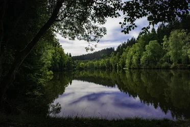
This marathon route leads from Lützel in the municipality of Hilchenbach on a scenic, varied, and trail-rich 42.3 kilometers with 670 meters of elevation through the Rothaar Mountains! And there is a lot to see: Rothaarsteig, Ginsburg, Rhein-Weser Tower, and more...
Waypoints
Start


Good to know
Best to visit
suitable
Depends on weather
Directions
The path leads from Hilchenbach Lützel over the Rothaarsteig to the Rhein-Weser Tower. From there, it goes via Rüspe, Röspe, Zinse, and Erndtebrück back to the starting point.
Tour information
Loop Road
Stop at an Inn
Equipment
Normal hiking equipment.
Directions & Parking facilities
Getting there
In Hilchenbach-Lützel, follow the B62 at the junction to the train stop.
Parking
There are sufficient parking spaces around the train stop.
Public transportation
Take the train from Bad Berleburg/Erndtebrück or from Siegen to the Hilchenbach-Lützel train stop.
Author
Frank Rother
Organization
Touristikverband Siegen-Wittgenstein e.V.
Author´s Tip / Recommendation of the author
Definitely enjoy the magnificent view from the Rhein-Weser Tower over the surrounding area!
Nearby


")


Download GPX file