Rothaarsteig route Trödelstein path


- 4:00 h
- 11.00 km
- 307 m
- 299 m
- 346 m
- 611 m
- 265 m
- Start: Burbach-Wahlbach hiking portal (Austraße, 57299 Burbach-Wahlbach) Not accessible this year (2024) due to construction. Please use the hiking portal in Buchhellertal. Access via Eicher Weg past the town hall!
- Destination: Circular route back to the starting point hiking portal Burbach-Wahlbach) Not accessible this year (2024) due to construction. Please use the hiking portal in Buchhellertal. Access via Eicher Weg past the town hall!
The start of our route is at the hiking car park on Austraße in Wahlbach.
(Not accessible this year (2024) due to construction. Please use the hiking portal in Buchhellertal. Access via Eicher Weg past the town hall!)
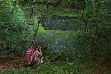
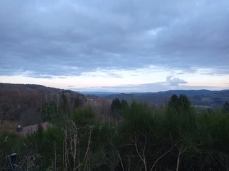
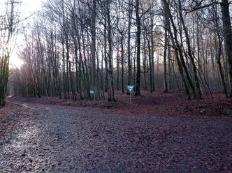
From there we follow the marking to the forest edge. We walk clockwise along a forest path beside the babbling Buchheller, which accompanies us at first. The trail bends at a right angle and we now begin the ascent to the Trödelsteine. Along the way, we encounter the witnesses of ore mining in the Buchhellertal: Stollenmunde and slag residues are relics from the mining era. The summit cross on the Trödelsteine greets us from afar. Upon reaching the summit, good weather rewards us with a view over the green Siegerland. Of course, we sign the summit book. Continuing along the path marked with a white, lying "R", we now go through a new section that has arisen due to the clearing of spruce stands. Upon reaching the Nenkersberg, a distant view opens to us that was not there before. The Eifel or Sauerland are clearly visible! After letting our thoughts wander, we now begin the descent. Shortly, we become border crossers between Rhineland-Palatinate and NRW and pass through narrow paths in mystical forests to the juniper heath in the Saukaute nature reserve. Shortly before the end of the route, we can once again enjoy the view of the unique landscape between Rothaar Mountains and Westerwald. Continuing over narrow paths that still require surefootedness, we return to Wahlbach.

Waypoints


Good to know
Best to visit
Directions
The start of our route is at the hiking car park on Austraße in Wahlbach.
(Not accessible this year (2024) due to construction. Please use the hiking portal in Buchhellertal. Access via Eicher Weg past the town hall!)
From there we follow the marking to the edge of the forest. We walk clockwise along a forest path beside the babbling Buchheller, which accompanies us at first, and gradually enter deeper into the forest. The trail bends at a right angle and we now begin the ascent to the Trödelsteine. Along the way, we encounter the witnesses of ore mining in the Buchhellertal: Stollenmunde and slag residues are the relics from the mining era. The summit cross on the Trödelsteine greets us from afar. Upon reaching the summit, good weather rewards us with a view over the green Siegerland. Of course, we sign the summit book. Continuing along the path marked with a white, lying "R", we now go through a new section that has arisen due to the clearing of spruce stands. Upon reaching the Nenkersberg, a distant view opens up to us that was not there before. The Eifel or Sauerland are clearly visible! After letting our thoughts wander, we now begin the descent. Shortly, we become border crossers between Rhineland-Palatinate and NRW and pass through narrow paths in mystical forests to the juniper heath in the Saukaute Nature Reserve. Shortly before the end of the route, we can once again enjoy the view of the unique landscape between the Rothaar Mountains and Westerwald. Continuing over narrow paths that still require surefootedness, we return to Wahlbach.
Tour information
Cultural Interesting
Loop Road
Equipment
Sturdy footwear, weatherproof clothing, and appropriate provisions are recommended for a hike on the Trödelstein path!
Surefootedness is necessary for the path sections.
Directions & Parking facilities
The starting point is the Austraße car park in the Burbach district of Wahlbach. Please enter "Austraße in 57299 Burbach" in your navigation system.
The starting point is the Austraße car park in the Burbach district of Wahlbach.
Not accessible this year (2024) due to construction. Please use the hiking portal in Buchhellertal. Access via Eicher Weg past the town hall!
- You can park your vehicle in the immediate vicinity of the fire station (Brückenstraße 2). You reach the Trödelstein path via the marked Rothaarsteig access path on Diesterwegstraße. Please follow the route towards Burbach.
- You can also park your vehicle in Buchhellertal. Please follow the signs "Trödelstein path" from Erzweg in Burbach.
- The hiking car park is located behind the first bridge over the Buchheller on the right-hand side.
Travel by train RB 96 is convenient. The stop is Wahlbach. From there, you reach the hiking route via the marked Rothaarsteig access path towards Burbach. You can also reach the circular route by bus. Get off at the stop "Schule" in Burbach-Wahlbach.
Not accessible this year (2024) due to construction. Please use the hiking portal in Buchhellertal. Access via Eicher Weg past the town hall!
Please use the Burbach station and then go via Eicher Weg to the Buchhellertal hiking portal.
More information on tickets and fares as well as timetable information can be found at the following link: www.zws-online.de
Additional information
After the hike, the restaurateurs are looking forward to your visit. Exchange your impressions over freshly prepared delights and a cool drink. Small snacks are offered by bakeries, butchers, and local food retailers.
- Restaurant Mythos, Wahlbach, telephone 02736-492155,
- Hotel-Restaurant Bechtel with a cozy beer garden, Wahlbach, telephone 02736-4179523 (Quality Rothaarsteig Operation)
- Pizzeria Restaurant "Picasso", Burbach, tel. 02736-4179377
Please inquire about the opening times of the businesses by phone. We wish you a lot of fun on your hike!
- For more information about the Rothaarsteig routes, visit www.rothaarsteig.de or call the free service hotline +49 2974/4994163.
- Tourist info in the Alte Vogtei, Ginnerbach 2, 57299 Burbach, tel. 02736/45-17 or -38, fax -55, www.burbach-siegerland.de
Uniform marking: white lying Rothaarsteig "R" on a black background
Literature
Hiking flyer: "ROTHAARSTEIG-SPUR Trödelstein Spur - Dance on the Volcano"
Author
Cornelia Oerter
Organization
Südliches Siegerland
License (master data)

Author´s Tip / Recommendation of the author
A combination of paths, forest passages, great views, and rushing water. At the Buchheller, cozy sections invite you to rest. Tip: Sign the summit book. Due to the bark beetle infestation, all spruce stands along the route had to give way, so please definitely remember enough sun protection and drinks.
Safety guidelines
Information on the rescue boards on the Rothaarsteig
Hiking trails usually run away from towns and settlements, and every hiker has at some point wondered what would happen if there was an emergency right now. How can I be found here? Where am I anyway? Can the rescue service reach me?
In an emergency, it must be quick! Therefore, the Rothaarsteig is continuously equipped with so-called rescue signs. On the green and white plaques attached to the posts of the signposts, there is a number you must give when making your emergency call. This way, the rescue workers know exactly where you are, and valuable time can be saved.
Please note that due to the dryness, there is currently an increased risk of forest fire! Therefore, please observe the following instructions:
Observe the legal smoking ban in the forest - it applies in spring, summer, and autumn, specifically from March 1 to October 31.
Observe the ban on open fires in the forest and within 100 meters of the forest.
Take glass out of the forest - The burning glass effect can cause forest fires.
If it's (too) late:
Extinguish small fires if it is safely possible for you. Check the site carefully if necessary.
Report fires via "112".
Leave the danger area by the shortest route.
The forest thanks you!
Map
Rothaarsteig hiking map
Hiking map of the municipality of Burbach
Nearby


Download GPX file