Rothaarsteig trail Romantic Hickengrund - Literature in Nature


- 6:15 h
- 22.99 km
- 491 m
- 498 m
- 315 m
- 591 m
- 276 m
- Start: Hiking car park Großer Stein / entry or route division possible: sports ground Lützeln & Hickengrundhalle car park
- Destination: Hiking car park Großer Stein / entry or route division possible: sports ground Lützeln & Hickengrundhalle car park
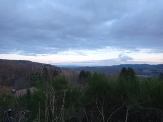
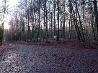
We start the route at the hiking car park “Großer Stein” in Holzhausen. Together with the Rothaarsteig access path, we hike uphill. In the immediate vicinity of the “Großer Stein”, we come to one of the seven listening stations. A few steps later, we meet the Rothaarsteig (RHS) there. We now turn left together towards Lützeln. Suddenly, the magnificent view of Lützeln, nestled down in the valley, opens up for us. After the descent to the edge of the village, the path rises again towards the sports ground. As a relic from the time of an active quarry, we later pass the old crushing plant. Following the entire route further, we turn right together with the RHS and reach the next highlight: the viewpoint at the kaolinite clay pit. After scenic, varied kilometers, we follow the path left to the forest. After 10 km, there is a rest area Höppches Hain with a great view to the left of the route. At the Three-Country Corner, we become border crossers. Wide forest paths then lead northwards along the northern flank of the Hickengrund. We continue to stay at elevation and head to the next viewpoint “Lonely Tree”. Soft meadow paths then accompany us downhill, although there are also steep sections to tackle. Shortly before Niederdresselndorf, we cross the stream by wooden bridge. After the village, we climb uphill through open meadows to the forest edge. On an almost level path, we return to the start at the hiking car park.

Waypoints


Good to know
Best to visit
Directions
We start the route at the hiking car park “Großer Stein” in Holzhausen. Together with the Rothaarsteig access path, we hike uphill. In the immediate vicinity of the “Großer Stein,” we come to one of the 7 listening stations. A few steps later, we meet the Rothaarsteig (RHS) there. We now turn left together towards Lützeln. Suddenly, the magnificent view of Lützeln, nestled down in the valley, opens up for us. As a relic from the time of an active quarry, we later pass the old crushing plant. Following the entire route further, we turn right together with the RHS and reach the next highlight: the viewpoint at the kaolinite clay pit. After scenic, varied kilometers, we follow the path left to the forest. At the Three-Country Corner we become border crossers. Wide forest paths then lead northwards along the northern flank of the Hickengrund. We continue to stay at elevation and head to the next viewpoint “Lonely Tree”. Soft meadow paths then accompany us downhill, although there are also steep sections to tackle. Shortly before Niederdresselndorf, we cross the stream by bridge. After the village, we climb uphill through open meadows to the forest edge. On an almost level path, we return to the start at the hiking car park.
Tour information
Cultural Interesting
Loop Road
Stop at an Inn
Equipment
Equipment and provisions for a day route and good footwear recommended. Surefootedness is necessary for the path sections, the route can be divided:
- North loop from Lützeln (15.5 km), entry at Lützeln sports ground, Hainshof
- South loop from Niederdresselndorf (14.7 km), entry at Hickengrundhalle Niederdresselndorf, Westerwaldstraße
Directions & Parking facilities
Full circuit: hiking car park Holzhausen at the natural pond / Großer Stein
North loop: sports ground Lützeln (Hainhof-Str.)
South loop: Hickengrundhalle in Niederdresselndorf
Convenient access by train is possible. Exit stops are Holzhausen or Niederdresselndorf. From there, you can reach the hiking route via the marked Rothaarsteig access path towards Burbach. You can also reach the circular route by bus. Exit stop “Hoorwaldstraße” in Burbach-Holzhausen
Further information on tickets and fares as well as timetable information can also be found at the following link: www.zws-online.de
Additional information
After the hike, the restaurateurs look forward to your visit. Exchange your impressions over freshly prepared delicacies and a cool drink. Small snacks are offered by bakeries, butcher shops, and the local grocery store.
- Restaurant “Zur Hickengrundhalle”, Niederdresselndorf, phone 02736/5093965,
- Hotel-Restaurant “Fiester Hannes”, Holzhausen, phone 02736/2959
- Pizzeria “Da Mimmo”, Holzhausen, phone 02736/299515
- Conference Center Karimu, Holzhausen, phone 02736/449660
- Family holiday center “Blue Cross”, Holzhausen, phone 02736/209-0
Please inquire by phone about the opening hours of the establishments. We wish you a lot of fun on your hike!
- Tourist Info at the town hall, room 123, Eicher Weg 13, 57299 Burbach, phone 02736/45-38 or -22, fax -55, touristinfo@burbach-siegerland.de, www.burbach-siegerland.de
Uniform marking: Rothaarsteig trail Romantic Hickengrund
Literature
Hiking flyer: "Literature in Nature - Romantic Hickengrund"
Author
Mario Otterbach
Organization
Südliches Siegerland
License (master data)

Author´s Tip / Recommendation of the author
The seven listening stations make the hike an unmistakable romantic experience! Visit the old schools in Niederdresselndorf or Holzhausen.
Safety guidelines
- Some sections run on steep paths that can be slippery when wet. Good surefootedness is then necessary. Hiking poles are helpful on these sections.
- Information about the rescue signs on the Rothaarsteig
Hiking trails mostly run away from towns and settlements, and every hiker has probably thought about what would happen if an emergency occurred now. How can I be found here? Where am I at all? Can emergency services reach me?
In an emergency, it must be quick! Therefore, the Rothaarsteig is continuously equipped with so-called rescue signs. On the green-white plaques attached to the posts of the directional signs, there is a number that you must provide when making your emergency call. This lets the rescue teams know exactly where you are, saving valuable time.
Map
Rothaarsteig hiking map
Map of the municipality of Burbach
Nearby


Download GPX file