Sonnenweg


- 3:12 h
- 11.85 km
- 203 m
- 203 m
- 396 m
- 598 m
- 202 m
- Start: Gasthof Jokebes
- Destination: Gasthof Jokebes
The Sonnenweg leads you from Gasthof Jokebes through the village Irmgarteichen, over the Josef-Pfad and the Irmgarteichener Weg to the Schützenhalle St. Hubertus. From Irmgarteichen, the path continues toward Hainchen. Through Hainchen you walk past the church and the water castle Hainchen. Via the Rothaarsteig access path, you reach the Rothaarsteig.
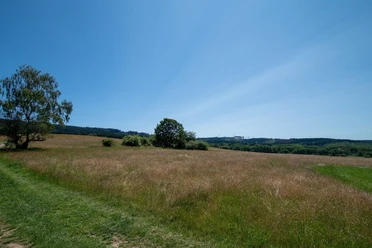
Past meadows and fields it goes in the direction of the Haincher Höhe hiking car park. Once you reach Haincher Höhe, it goes down into the valley again. Back in Irmgarteichen, the path leads you below Pfarrberg. Here, enjoy unique views over the landscape. A highlight of the route is the 13 m long, sun-yellow painted bench. This offers space for 22 people. The Sonnenweg is consistently marked with a circled I.
Waypoints

Good to know
Best to visit
Directions
From the starting point of the route, we turn left behind the Gasthof Jokebes into Gängelweg. After 200 m, this meets the main road (Koblenzer Straße). Ahead of us lies the village square Imgarteichen. We turn right into a small dead-end path. After 100 m, we turn right and follow the street. At the end of the development, it turns into a field path. We follow the Josef-Pfad. At the next intersection, we take the left field path. We meet the Irmgarteichener Weg. We follow this to the right until the main road.
We cross the main road and follow the street Auf der Struth. After 200 m, we see the Schützenhalle Irmgarteichen on the right side. Here we turn left and shortly afterwards at the junction take the left farm road. We follow the old sheep path for the next 800 m and reach the entrance to Hainchen. The path turns to asphalt. The Meisenweg leads us to the main road (Gießener Straße). Here we keep to the right, past the chapel in Hainchen and across the village square with village fountain.
After 100 m, we turn right into Schloßstraße. This leads us past the water castle Hainchen until after 400 m we reach the main road (Gießener Straße) again. We cross it and follow the Rothaarsteig access path, which leads us higher into the forest via an ascent. After 2.5 km we reach the Rothaarsteig. Here we keep right and hike on the Rothaarsteig and cross the main road again after 2.5 km. After 100 m, we leave the Rothaarsteig to the right and hike 1 km down through spruce forest until we meet the main road again. We walk 50 m on the main road and then immediately turn left into an asphalted path. This leads us to the Hainchen hiking car park. We pass the barrier and take the left path at the crossroads.
After 700 m we see an agricultural farm on the right side. We pass it and take the left narrower farm road at the fork. We follow this through the fields until after 500 m we reach the main road. We cross it and follow the asphalted path. Directly behind the next intersection after about 300 m, we choose the field path through the meadows on the right side. We now hike below the Pfarrberg and after 500 m see the large yellow sun bench on the left side, which invites you to linger.
After 100 m we meet a wider farm road. Here we keep right. We walk along the Irmgarteichen cemetery and past the Saubraas barbecue area. We follow the path to the end and take the right small field path through the meadows at the forest edge. After 200 m we reach the Heiligenhäuschen and turn right. After 100 m we keep right again and hike along the cross path back to the starting point.
Tour information
Loop Road
Stop at an Inn
Equipment
Directions & Parking facilities
From the ZOB in Siegen you can easily reach the starting point of the hike with Line R16 Siegen-Weidenau-Netphen-Deuz-Hainchen, bus stop Irmgarteichen Kirche. From there you reach the inns Jokebes and Ley after a short walk.
Further information can be found at:
Additional information
Amtsstraße 2+6
57250 Netphen
+49 2738 603-238
touristikbuero@netphen.de
www.netphen.de/tourismus
Author
Sarah Grübener
Organization
Touristikverband Siegen-Wittgenstein e.V.
License (master data)

Author´s Tip / Recommendation of the author
A visit to the Hainchen water castle with a tasty stop at the Remise (open Sundays) is worthwhile.
Nearby


Download GPX file