Views - Vistas - Circular hike around Neunkirchen


- 11:00 h
- 39.43 km
- 904 m
- 904 m
- 243 m
- 490 m
- 247 m
- Start: Hiking portal "Steimel", Bhf. Struthütten or stop Familienbad Neunkirchen - Salchendorf
- Destination: Hiking portal "Steimel", Bhf. Struthütten or stop Familienbad Neunkirchen - Salchendorf
From the hiking portal Steimel, we hike to Pfannenbergkopf with its historic observation tower from 1934. Here, a beautiful panoramic view opens up from the nearly 20-meter-high observation platform. After a break at the snack station, we continue downhill past Königseiche towards the swimming pool.
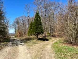
The path crosses the "Bähnchensweg", frequented by many cyclists and joggers. Over the spoil tip "Junger Löwe", we reach the district Wiederstein. The school forest informs us about numerous tree species, and a nice rest stop invites us shortly afterwards to pause again with a great view over the village.
On the Luisenpfad past the Wiederstein memorial, we hike to the Malscheid nature reserve and are soon rewarded with a wonderful view of the Silbersee. Hohenseelbachskopf reminds us of past mining days. Afterwards, we return to Steimel.
How wonderfully art and nature harmonize is demonstrated by the most beautiful artist path around Neunkirchen. 18 paintings and sculptures by local artists have been installed on this short route.
Waypoints


Good to know
Best to visit
Directions
We start at one of the three "hiking portals" that serve as entry points to the nearly 40-kilometer-long route. One of these hiking portals is located in the former mining area Steimel (405m). From here, it goes to Pfannenbergkopf (499m) and then past the Große Rausche by the Königseiche heading towards the swimming pool.
Below Leyenkopf and Rassberg, we continue hiking. We cross the Bähnchensweg and reach the district of Wiederstein via the spoil tip "Junger Löwe".
The adjoining Luisenpfad leads us downhill again past the Wiederstein memorial. We continue on the well-signposted path towards the Malscheid nature reserve to Hohenseelbachskopf. Impressed by these sights, we go downhill again to shortly thereafter complete the last stage back to the starting point Steimel in the Kunstertal area.
Tour information
Cultural Interesting
Loop Road
Stop at an Inn
Equipment
- Day hiking backpack (approx. 20 liters) with rain cover
- Sturdy and comfortable footwear
- Weather-appropriate and durable layered clothing
- Telescopic poles if needed
- Sun and rain protection
- Provisions and drinking water
- First aid kit
- Pocket knife
- Mobile phone
- Headlamp if needed
- Map material
Directions & Parking facilities
The Hellertalbahn is connected with the DB train stations Betzdorf, Haiger, and Dillenburg
The train stop Bhf. Struthütten lies directly on the path, about a 30-minute walk from Bhf. Neunkirchen to the entry above the family pool
Bus R22 and R23 to Siegen.
Additional information
Tourist Info Neunkirchen Town Hall
Room 415, Bahnhofstr. 3
57290 Neunkirchen
Tel. 02735/7 67-425
s.berg@neunkirchensiegerland.de
www.neunkirchen-siegerland.de
Author
Natalie Glatter
Organization
Südliches Siegerland
License (master data)

Author´s Tip / Recommendation of the author
The detour to the Malscheid nature reserve is definitely worth it!
Map
Bicycle hiking and leisure map Siegerland-Wittgenstein, with guide booklet, 1:50,000
Our recommendations
Nearby


Download GPX file