Wilden circular route

9.84 km long
Round trip
Difficulty: medium
Condition: easy
Regional hiking trail
  • 2:46 h
  • 9.84 km
  • 195 m
  • 195 m
  • 315 m
  • 419 m
  • 104 m
  • Start: Community center Wilden
  • Destination: Community center Wilden
The approximately 10 km long circular route runs around the Wilnsdorf district of Wilden and offers beautiful views of the district.

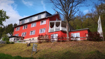
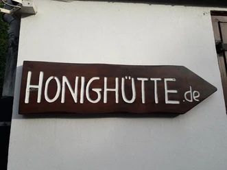
The Wilden circular route has a connecting path that divides it into two shorter stages. The parking lot at the community center serves as a starting point for both sections. Part of the route runs along the Schulwald and features many benches as well as beautiful views of the district. In the west, south, and east, the larger circular route partly follows regional paths. A guesthouse offers the possibility to stop for refreshments and overnight stays.

Waypoints

Start
Community center Wilden
CC-BY | Elfi Jung, Gemeinde Wilnsdorf
CC-BY | Gästehaus Engel

Good to know

Best to visit

suitable
Depends on weather

Directions

We start our hike at the parking lot of the community center in the village center of Wilden and continue walking north to reach the main path. Along the way, we pass the village smithy. Once on the main path, the route leads us westward through Mittelwilden to the Schulwald. After enjoying the beautiful view of Wilden, we cross the L722 and continue uphill. Open fields and meadows accompany us until we reach the Landeskrone industrial area, where we cross the L723. The path runs parallel to the A45 until we cross the L723 again. A bridge then takes us back to the northern side of the L722. Here, a detour to the truck stop is possible, where the architecturally special motorway church can be visited. Below the Elkersberg, the path leads us back to the connecting path and our starting point. At the end, we can stop at the Gästehaus Engel.

Tour information

  • Cultural Interesting

  • Loop Road

  • Stop at an Inn

Equipment

No special equipment is required for the hike.

Directions & Parking facilities

From Wilnsdorf Zentrum or the A45 via the L722 towards Wilden.
Parking is available at the hiking parking lot below the A45 on the L723 and at the community center in Wilden (Im Strüthchen).

From Rudersdorf station, take bus line R13 to Wilnsdorf Zentrum

From Wilnsdorf Zentrum, take bus line R12 to Mittelwilden community center

Information from ZWS (Zweckverband Personennahverkehr Westfalen-Süd), Tel.: 01806/504030 (€0.20/call from landline, mobile max. €0.60/min)

Additional information

Municipality of Wilnsdorf

Marktplatz 1

57234 Wilnsdorf

Tel. 02739/802-0, Fax -139

rathaus@wilnsdorf.de

www.wilnsdorf.de

Author

Lena Wildfeuer

Organization

Südliches Siegerland

License (master data)

License: Attribution, ShareAlike

Author´s Tip / Recommendation of the author

Place to eat: Gästehaus Engel in Wilden

Map

Cycle touring and leisure map Siegerland-Wittgenstein with accompanying booklet, scale 1:50,000, ISBN 3-87073-280-3, €7.95

Hiking map Southern Siegerland, scale 1:25,000, €7.95

Nearby

Contact

Wilden circular route
Am Hilchenbach
57234 Wilnsdorf