A4 Flammersbach


- 1:22 h
- 4.76 km
- 136 m
- 136 m
- 275 m
- 371 m
- 96 m
- Start: Hiking parking lot at Flammersbach sports field
- Destination: Hiking parking lot at Flammersbach sports field
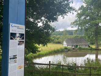
Besides some forest sections, the hiker on the ridge between Niederdielfen and Flammersbach on the Jakobsweg also has a wonderful view of the two districts. The scenically beautifully located Niederdielfen watermill with mill pond and millrace is a prime example of milling technology from the early 18th century.
Waypoints

Good to know
Best to visit
Directions
Tour information
Cultural Interesting
Loop Road
Equipment
Directions & Parking facilities
Coming from Siegen via L719 and K11 to Flammersbach
Coming from Wilnsdorf via L723 to Niederdielfen
Additional information
Municipality of Wilnsdorf
Marktplatz 1
57234 Wilnsdorf
Tel. 02739/802-0, Fax -139
Author
Lena Wildfeuer
Organization
Südliches Siegerland
License (master data)

Author´s Tip / Recommendation of the author
Map
Bike hiking and leisure map Siegerland-Wittgenstein with guide booklet, 1:50,000, ISBN 3-87073-280-3, €7.95
Hiking map Southern Siegerland, 1:25,000, €7.95
Nearby


Download GPX file