Bike route Over the Villages - Around Burbach


- 3:00 h
- 28.40 km
- 395 m
- 385 m
- 333 m
- 616 m
- 283 m
- Start: Town hall of the municipality of Burbach
- Destination: Town hall of the municipality of Burbach
The route through the Burbach villages starts at the Burbach town hall on Eicher Weg. After preparing your bicycle, cycle through the harmoniously designed village center towards Würgendorf. From the mighty "Römer," the Evangelical Church of Burbach towers, which is worth visiting. Through Nassauische Straße and with a short detour via Jägerstraße, turn left into Gassenweg. On the right, you see the "Alte Vogtei," where changing exhibitions of regional and supraregional artists can be admired. The "Alte Vogtei" is around 500 years old and one of the most impressive half-timbered buildings in Siegerland.
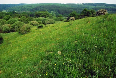
Now continue to Würgendorf. Gently ascending, follow the route through Hellerauen. The quiet babbling of the Heller accompanies you along the way. In Würgendorf, a detour into the village center to the defensive church and the Heimhof Theater Burbach is worthwhile. Leaving Würgendorf behind, cycle through a lush green beech forest to Holzhausen. The half-timbered ensemble around the "Alte Schule" with a nature study room, local history room, and the church is worth a rest. Then continue through Holzhausen towards Niederdresselndorf. Here, too, the equally historic village center is worth admiring. The church of Niederdresselndorf also invites you to pause. Via the signed cycle path, you reach Oberdresselndorf. You leave the village and reach the open landscape of Hickengrund. This special natural area impresses the landscape. Not without reason, 31 nature reserves and a European bird sanctuary are designated in Burbach. Hazel grouse and black stork are just some rare animal species to admire. Before a magnificent view of Liebenscheid opens, you leave North Rhine-Westphalia. Via an ascent, you come to Rhineland-Palatinate. At the top, you meet the Rothaarsteig, a magnificent view. On the left, you notice the approach lighting of Siegerland Airport. Through Liebenscheid, past the small church, it goes over the barbecue hut towards Lippe. On the right is Siegerland Airport. Scenic flights and parachute jumps are possible here. Back on the bike tour, you cross the B54 and turn to Lippe, the southernmost village in Westphalia. Past the village community center, a rapid descent leads through the Buchhellertal. This special spot still shows relics of the Siegerland mining tradition. Before that, spectacular views can still be enjoyed in clear weather. After leaving the Buchhellertal, you come along lush green meadows and the Buchheller river flowing on the left in the valley back to the starting point at the town hall.

Waypoints


Good to know
Best to visit
Directions
The route through the Burbach villages starts at the Burbach town hall on Eicher Weg. After preparing your bicycle, cycle through the harmoniously designed Burbach village center towards Würgendorf. From the mighty "Römer," the Evangelical Church of Burbach towers, which is worth a visit. Through Nassauische Straße and with a short detour via Jägerstraße, turn left into Gassenweg. On the right, you see the "Alte Vogtei," where changing exhibitions of regional and supraregional artists can be admired. The "Alte Vogtei" is around 500 years old and one of the most impressive half-timbered buildings in the Siegerland.
Cycle along Gassenweg to the roundabout in Jägerstraße. Leave the roundabout at the fourth exit and shortly after the railway crossing turn right onto the signed bicycle path towards Würgendorf. Pass the Burbach sports field and cross Carl-Benz-Straße. Please follow the red-white bicycle route signs. Gently ascending, follow the route through the Hellerauen to Würgendorf. The quiet babbling of the Heller accompanies you along the way. Upon arrival in Würgendorf, the signposts of the cycling network show you the way to Holzhausen via Gartenstraße and Werkstraße to Sangstraße. Here, a short detour to the Heimhof Theater is worthwhile. Cycle along Sangstraße further to L 531. For a short distance, use the road as a cycle path to shortly after the B54 underpass where you turn into a paved forest path. Now follow the path to the left through the wonderfully fresh beech forest. At the next fork, keep right slightly uphill. Then at the next fork follow the route downhill to Holzhausen. Ahead lies the Wycliff Center. Bypass it on the left and then you will meet the railway line of the Hellertalbahn. Follow it to the railway underpass, then turn left and cycle downhill through "Siegenweg" into the historic village center of Holzhausen. Here you leave the routing of the Radnetz NRW cycling network. Ahead lie the "Alte Schule" of Holzhausen and the hotel "Fiester Hannes." A stop and rest are worthwhile here. Cycle through Hoorwaldstraße to just before the Holzhausen industrial area. Here turn left into the "Neue Siedlung." Shortly after, about 250 m, turn right and cycle below the sports field on a paved cycle path through green meadows to Niederdresselndorf. You are now back on the signed cycle path of the Radnetz NRW. Follow the signs through the historic village center of Niederdresselndorf towards Oberdresselndorf and Liebenscheid. You pass under the viaduct of the Hellertalbahn and come past the Oberdresselndorf cemetery. There you meet Westerwaldstraße. At the outskirts of Oberdresselndorf, follow the cycle path on the left into the impressive nature of southern Siegerland. At the Buchenborn hiking car park, it is advisable to refresh yourself before tackling the ascent to the left towards Liebenscheid. You cross the Wetterbach and now follow the paved road uphill. On the left is a farm. At the top, the approach lighting of Siegerland Airport flashes on the right. A magnificent view of the landscape compensates for the effort of the ascent. Shortly after, you come to the Rothaarsteig, which you cross and continue along the paved road towards Liebenscheid. In the attractive village center, turn left, cycle past the small church. You meet the state road, cross it, and turn diagonally left onto the paved path to the Liebenscheid barbecue hut.
Follow the path further, past the first junction, through a cool spruce stand. Ahead, the view opens up to Siegerland Airport. A detour here is worthwhile to watch landing or departing planes, watch parachutists or perhaps take a scenic flight yourself.
Otherwise, the path leads again along the cycle route signs. At the roundabout, cross the B54 towards Burbach-Lippe. Lippe is the southernmost village in Westphalia. Then continue through the village, following the cycle path signs past the cemetery downhill. Before that, an breathtaking view opens up to the forest richness of Siegerland. Now it goes downhill into the Buchhellertal. At the small fish pond, keep left to experience the ruin of Peterszeche. The Buchhellertal shows the history of Siegerland. Various ores were mined here in the past, as in many areas of the more than 2,000-year-old mining region. Past the small forest chapel, continue downhill along the paved road. You cross the Buchheller river and on the left lies the Nenkersberg forest estate. Via "Buchhellerstraße" you return to "Eicher Weg," the starting point of the route.
Tour information
Cultural Interesting
Loop Road
Stop at an Inn
Equipment
There are various catering options along the route:
Burbach:
- Pizzeria Picasso
- Bakery Café Rothe
Würgendorf:
- Hotel-Restaurant "Windeck"
Holzhausen:
- Hotel-Restaurant "Fiester Hannes"
Niederdresselndorf:
- Bakery Rothe
Lippe:
- Restaurant Café "Toscana-Stübchen" at Siegerland Airport
Directions & Parking facilities
You can easily reach the starting point of the route with the Hellertalbahn to
- Burbach station or
- Würgendorf station
The core town of Burbach is also connected to public transport by several bus lines.
Timetable information and fares are available at www.zws-online.de. You can conveniently use the guest ticket x or XL for your arrival.
Additional information
Further information is available from the municipality of Burbach, Tourist Information, Ginnerbach 2
Tel.: 02736/4581
E-mail touristinfo@burbach-siegerland.de
Homepage www.suedliches-siegerland.de
Author
Tim Lehmann
Organization
Südliches Siegerland
License (master data)

Author´s Tip / Recommendation of the author
- Heimhof Theater Burbach-Würgendorf Click here
- Guided tours "Experience Siegerland Airport" Click here
Safety guidelines
Map
Village map of the municipality of Burbach
The route is part of the South Westphalia cycle network and is marked with a uniform insert bearing the logo "Over the Villages."
The approximately 27 km long route starts at Burbach town hall on Eicher Weg. From there, you cycle through the village center further along the cycle path to Würgendorf and then to Holzhausen (KP 36). Then on to Niederdresselndorf (KP 35), Oberdresselndorf, and via the cycle path through Buchenborn to Liebenscheid. From there, further uphill to Lippe (KP 34) and through the Buchhellertal back to Burbach (KP 33). Charming villages nestled between lush green meadows and romantically wild deciduous and coniferous forests lie along the route.
Junctions 33 – 36 – 35 – 34 – 33, starting point Town Hall Burbach, Eicher Weg 13
Nearby


Download GPX file