F1 local hiking route Feudingen "Through the Auerbach valley along the Mackelshelle"


- 2:02 h
- 7.18 km
- 194 m
- 194 m
- 388 m
- 548 m
- 160 m
- Start: Hiking sign at the Volksbank Feudingen
- Destination: Hiking sign at the Volksbank Feudingen
The circular route F1 leads through the Auerbach valley along the Mackelshelle back to Feudingen.
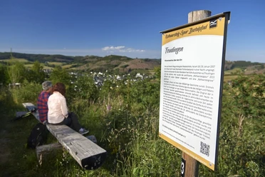
The hiking route F1 starts at the hiking sign at the Volksbank Feudingen and runs past the bakehouse towards the Volkshalle to the Vesper island. There the hiker is offered an information board and a seating area. We follow the F1 further into a side valley of the Upper Lahn, the Auerbach valley, with a view of the forester's house. From there it continues along the Auerbach towards Sprünge. Here the hiker again finds a rest area. On the next challenging ascent towards Höhenwegskopf, the hiker's stamina is tested. After the descent along the Mackelshelle, we pass the Vesper island with the information board again and return to the hiking sign at the Volksbank Feudingen.

Waypoints


Good to know
Best to visit
Directions
Tour information
Loop Road
Stop at an Inn
Equipment
Directions & Parking facilities
The journey to Feudingen can be made by train to Feudingen station and then approximately 150 meters on foot to the left to the hiking sign at the Volksbank. By bus, you can travel directly to the hiking sign at the Volksbank at the "Feudingen Ortsmitte" stop.
Further information on connections can be found at:
Additional information
This route is maintained and marked by the SGV Oberes Lahntal Feudingen e.V.. Various accommodation and dining options can be found on the club's homepage.
Author
Hans-Joachim Schmidt
Organization
Touristikverband Siegen-Wittgenstein e.V.
License (master data)

Safety guidelines
Nearby


Download GPX file