Rothaarsteig trail Ilsetalpfad


- 5:00 h
- 15.91 km
- 396 m
- 396 m
- 394 m
- 629 m
- 235 m
- Start: Hiking portal in Feudingen (street: "Zum Eichholz")
- Destination: Hiking portal in Feudingen (street: "Zum Eichholz")
Nature offers us the most beautiful moments.
The Rothaarsteig trail "Ilsetalpfad" has some of these to offer. They line up like pearls on a string. Wide views over the surrounding mountainous region, panoramic views guaranteed at several points. Wildly romantic valley passages on enchanted paths, embedded by massive pristine rock formations, which make the path appear mystical at times. Accompanied by the happily babbling Ilse or the Weidelbach. Following this leads to the shore of the Weidelbacher Weiher, whose sight makes everyone pause. Quite unexpectedly, it welcomes you in the middle of the forest with heavenly silence, its water lily splendor in summer, and countless great impressions from every angle. Those who can part ways quickly reach the historic shelter at the Bettelsmannsbuche. Before that, another landscape highlight is traversed, the passage through a so-called sunken lane. Afterwards, it continues varied over forest roads and paths along the slope of the young Lahn, the view becomes more open and extends far over the Lahn valley. But a view nearby is also worthwhile, as a large bison enclosure is passed in Dernbach and, with a bit of luck, the impressive animals stand very close to the fence.

Waypoints


Good to know
Best to visit
Directions
We begin the beautiful hike at the hiking portal "Zum Eichholz" in Feudingen and ascend to the slope of the Mackelshelle. Right at the start, we are greeted by the entrance portal to the "Alley of the Trees of the Year", which opened in 2022, leading us past the "Rothaarsteigrose". Here, a first view of the historic place Feudingen opens up. The trees are equipped with information boards that reveal quite a lot about the different trees to the interested nature lover. Along the entire route, new information boards have also been installed at significant waypoints. We continue past the "Old Sports Field", leisurely ascending to the Hohe Ley, where an impressive panoramic view over the wide Lahn valley awaits us. After an open high plateau with views of the Wittgenstein mountains, the path leads down into the wildly romantic Ilse valley. The path, later a enchanted trail, follows along a steep bank next to the rushing creek bed of the Ilse to the confluence of the Weidelbach. We follow this to the right, uphill to the Weidelbacher Weiher. The heavenly silence of the lake with its water lily splendor in summer invites a lengthy break. Afterwards, we hike over the shelter and the rest stop "Bettelmannsbuche"—where pilgrims and carters once stayed—across to the Lahn valley.
Shortly before reaching the "Bettelmannsbuche" we pass through an extraordinary landscape highlight, which was even listed as a cultural monument in 2016. It is a passage through a so-called sunken lane, probably part of a historic medieval trade route between Feudingen and Siegerland. Between the 17th and 19th centuries, Siegerland iron ore was transported on this path to the smelting furnaces in Feudingen, and on the return trips, charcoal from the Wittgenstein forests was loaded for wood-burning stoves and hammer mills in Siegerland. A horse pulled a single-axle cart, causing tracks to form that gradually dug deeper into the ground over the years. Additionally, water flowing through channels hollowed out the path further. The tracks dug ever deeper until the rims of the carts struck the sides of the sunken lane and could no longer go further, so new paths had to be used repeatedly over the years.
Later, we continue along the slope of the young Lahn towards Volkholz. In Dernbach, the forest opens up, offering not only wide views of the natural Lahn valley that are best enjoyed on a long bench. Here, we also pass a large bison enclosure, and although trees and bushes provide plenty of shelter for the animals, they can often be spotted and admired. The bison is a species of cattle and the largest and heaviest land mammal in Europe!
We are now almost at the end of the varied hike. A short path through Feudingen brings us back to the hiking portal and our starting point.
Tour information
Loop Road
Stop at an Inn
Equipment
The Rothaarsteig leads over numerous natural paths away from agricultural and forestry roads. Therefore, weatherproof clothing and sturdy footwear are a must for every hike. We want you to experience the “path of the senses” not only “dry” but also on “good” feet.
In our small hiking shop at rothaarsteig.de/shop, you will also find a selection of Rothaarsteig items to prepare for your route or as souvenirs. We gladly also recommend the durable and high-quality outdoor equipment from our long-term partner, the German outdoor outfitter Tatonka.
Hiking backpack
With a suitable hiking backpack, your tour on the Rothaarsteig is twice as much fun! Hiking backpacks offer very comfortable carrying properties thanks to a ventilated carrying system, which ensures that sweat can evaporate immediately. They can be fixed with a belly or hip belt and therefore sit firmly on the back during every movement. They are also equipped with a practical holder for hiking poles and often also have a compartment with an outlet for a hydration bladder to ensure fluid supply at all times.
Rainwear
If changeable weather is forecast for your tour on the Rothaarsteig, remember to pack a light rain jacket or rain poncho. They take up almost no space in your backpack and also shield against unpleasant wind. Practical are also gaiters that protect the trouser legs from dirt and moisture.
With our partner the German outdoor outfitter Tatonka, you will find high-quality, breathable rain jackets with minimal packing size, light rain capes, and gaiters for the trouser legs to protect them from dirt and moisture.
Here you can find the rain jackets from Tatonka for women
The rain jackets from Tatonka for men can be found here
First aid kit
To fully enjoy your hiking tour on the Rothaarsteig, a first aid kit should definitely be in your backpack. After all, there is nothing more annoying than not being able to immediately and cleanly treat a blister or small injuries.
The first aid kits from the German outdoor outfitter Tatonka are filled with all essential materials for the first treatment of injuries and also include an “outdoor cheat sheet” with a concise and clear guideline for correct behavior in emergencies in the wilderness. Here you can find the first aid kits from Tatonka!
Food and drinks
On some stages, especially between Lahnhof and Dillenburg, there are unfortunately no places to stop for refreshment. Please remember to especially pack food and drinks here. Particularly in summer, sufficient drinks are important.
Directions & Parking facilities
Feudingen is easily accessible by public transport. For detailed connection information, please see
From Siegen:
By bus from ZOB Siegen:
- SB5 (direction Bad Laasphe station) to Feudingen town center: approx. 54 min.
- About 10 min. walk to the hiking portal
By train from Siegen station:
- RB93 (Rothaar-Bahn, direction Bad Berleburg) to Erndtebrück: approx. 56 min.
- Short transfer time (< 5 min.)
- RB94 (Upper Lahn Valley Railway, direction Marburg) to Feudingen: approx. 19 min.
- About 10 min. walk to the hiking portal
We recommend using public transport at the start of your tour and positioning a car at the end point. This way, you don’t have to align your hike with the bus/train schedule.
Additional information
Tourist information of TKS Bad Laasphe GmbH
in the Haus des Gastes
Wilhelmplatz 3
57334 Bad Laasphe
Tel.: +49 2752 898
www.tourismus-badlaasphe.de
For refreshment before and after your walk, you have the following options in Feudingen and the surrounding area:
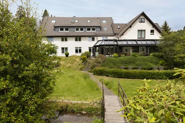
- Hotel im Auerbachtal / Feudingen: Phone 0 27 54 / 375 880
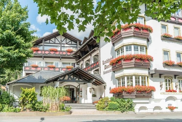
- Landhotel Doerr / Feudingen: Phone 0 27 54 / 37 00
- Lahntal-Hotel / Feudingen: Phone 0 27 54 / 267
- Jagdhof Glashütte / Glashütte: Phone 0 27 54 / 39 90
Please inquire by phone about the opening hours of the establishments. We wish you lots of fun on your hike!
Blog posts about the Ilsetalpfad:
Further information about the Rothaarsteig can be found at www.rothaarsteig.de and by phone on the free service hotline at +49 2974 / 499 4163. We are happy to advise you on your personal tour planning.
Literature
To prepare for your hike, we are happy to send you our free information package. At rothaarsteig.de you can easily select which information you need. A good companion for every tour is our Rothaarsteig guide with the hosts along the trail and other useful information.
Author
Petra Markus
Organization
Touristikverband Siegen-Wittgenstein e.V.
License (master data)

Author´s Tip / Recommendation of the author
In sunshine, the Weidelbacher Weiher is a power place and a place of contemplation.
Safety guidelines
Information about the rescue boards on the Rothaarsteig
Hiking trails usually run away from towns and settlements, and every hiker has at some point wondered what would happen if there were an emergency now. How can I be found here? Where exactly am I? Can emergency services reach me?
In an emergency, speed is crucial! Therefore, the Rothaarsteig is continuously equipped with so-called rescue signs. On the green-white plaques attached to the posts of the signposts, there is a number that you must provide when placing your emergency call. This way, the rescuers know exactly where you are, saving valuable time.
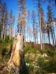
Notice regarding increased forest fire risk
Please note that due to dryness there is currently an increased risk of forest fire! Therefore, please observe the following guidelines:
- Observe the legal smoking ban in the forest - it applies in spring, summer, and autumn, specifically from March 1 to October 31.
- Observe the prohibition of open fire in the forest and within 100 meters of the forest.
- Take glass out of the forest—the burning glass effect can ignite forest fires.
If it is (too) late:
- Extinguish small fires if safely possible. Check the area carefully if necessary.
- Report fires by calling "112".
- Leave the danger area by the shortest route.
The forest thanks you!
Bison and wildlife on the Rothaarsteig – behavioral tips
Many wildlife species live in the forests along the Rothaarsteig. Encounters with red deer, wild boar, mouflon, and for some time also bison are possible. The latter can be encountered on the Rothaarsteig between Albrechtsplatz and Dreiherrenstein.
The risk the bison pose to the normal hiker is low and can be minimized to almost zero by appropriate adapted and respectful behavior.
- Walk calmly and discreetly at a distance past the animals, do not startle them and do not look directly into their eyes.
- If the animals approach you, stay calm, do not turn your back to them, and leave the area without panic but always keeping sight of the animal.
- If the animals cross a distance that makes you feel uncomfortable, shout loudly, whistle, or make other acoustic signals. Watch for threats!
- If wild boars "clatter their teeth" or bison lower their heads, they expect you to withdraw. Step back!
- If you have a dog, keep it under control on a leash. If an animal attacks your dog, unleash it! The dog is faster and more agile than you and will definitely find you again!
Map
In our brochure “Rothaarsteig-Spuren - All circular hiking routes at a glance” you will find map excerpts and short explanations for all 13 circular hiking routes, including a map for the Breitscheid cave tour. Furthermore, this brochure also features the other 12 Rothaarsteig-Spuren routes with maps, brief explanations, and the most beautiful rest spots along the route. You can conveniently and free of charge order the booklet to be delivered to your home or view it online as a PDF or flip catalog at rothaarsteig.de.
We also recommend our Rothaarsteig-Spuren hiking pass. Those who have completed 8 of the 13 routes receive a hiking certificate and a Rothaarsteig pin and participate in our annual raffle. You can also easily and free of charge order the hiking pass to be delivered to your home or download it directly online at rothaarsteig.de.
The original Rothaarsteig hiking map at a scale of 1:50,000 printed on waterproof paper, with the current trail routing and useful markings such as shelters, parking lots, bus stops and more, can be ordered free of shipping costs for 11.00 Euros at rothaarsteig.de conveniently to your home.
Nearby


Download GPX file