F3 - Circular Hiking Trail Büschergrund (long route)

- 3:35 h
- 13.19 km
- 216 m
- 216 m
- 284 m
- 452 m
- 168 m
- Start: Parking lot at the outdoor pool (circular trail)
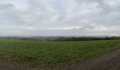
Over a distance of just over 13 kilometers, the F3 hiking trail leads around the Freudenberg district of Büschergrund - including an impressive panoramic view from the Ischeroth at over 400m altitude.
A good starting point is the outdoor pool in Freudenberg; other starting points are Drei Eichen, Löffelberg, Bühler Höhe/Wilhelmshöhe, or Bottenberg.

Waypoints


Good to know
Best to visit
Directions
We start at the outdoor pool parking lot and head right along the forest by the Gambach. Before fully entering the forest, we follow the hiking trail to the right, going uphill. This initial ascent gives us several elevation meters right at the beginning, so that in the further course we no longer have to master such steep climbs. Once we have reached the paved road at the top of the rise, we turn left onto a forest and meadow path. We follow this to the hiking parking lot "Drei Eichen," which already offers some views of Büschergrund. Passing the parking lot, we continue straight ahead for quite a while until the first wind turbine. Shortly before the wind turbine, we can take a detour into the walkable hollow path "Ohrndorfer Schlag."
Once we have passed the wind turbine, we turn half-right and follow the trail with its beautiful view over Büschergrund to Löffelberg. Arriving at the top, we can see houses through the forest. At this point, we turn right onto a new path that leads us to the main road. Here, too, we orient ourselves to the right and follow the road for about 400 meters. At the next larger intersection with forest paths, we leave the road again, go half-left into the forest, and follow the path to the four-way intersection. At the intersection, we turn right towards Büschergrund, so that later we come to the "Büscher Schlag." Shortly after the "Büscher Schlag," we go left along the forest edge in the direction of the motorway. We follow the F3 signage to the motorway bridge and cross it. On the ensuing path, we first keep left and then right until a large T-junction, where we continue following the Höhenring to the right. At the next intersection, we keep right again and follow the path uphill until the village of Bühl lies to our left and we reach the Ischeroth, whose summit rewards us with a fantastic view of Siegerland and Sauerland.
Now we leisurely descend towards Wilhelmshöhe. At the next waypoint, we keep left and reach the Bühler Höhe industrial area after about 500 meters. Here we follow the F3 signage towards the main road, there we turn right, cross the motorway again, pass by XXXLutz, and come to the main intersection. The route continues towards Waldhotel. Just before the hotel, we turn right, cross Alte Eisenstraße, and reach a fork where we keep right to then immediately turn left again to continue along the path towards the forest.
The last noticeable climb of this circular tour follows:
We continue towards Bottenberg. Before an agricultural building, we turn right onto a small path and follow it up to a paved road that leads us to Bottenberger Höhe. Arriving in town, we turn right, cross the street, and go straight ahead. Now a short passage with narrow paths awaits us. We pay attention to the F3 signs and safely make our way towards Johann-Moritz-Straße. For this, we turn right from the meadow path into the Niederwald and follow the paths until we reach wider trails and hike these downhill. Arriving at Johann-Moritz-Straße, we continue straight towards Siegener Straße. At Siegener Straße, we turn left and follow the road to the Siegener Straße - Olper Straße junction. After crossing the intersection straight ahead, we briefly follow Mühlenstraße and then turn left onto the Wasserstaaten-Weg, which takes us past the beautiful Gambachsweiher back to our starting point at the outdoor pool.
Tour information
Loop Road
Stop at an Inn
Equipment
Sturdy footwear, weather-appropriate clothing, rain protection, snacks for the way
Directions & Parking facilities
Parking lot at the outdoor pool
P&R Wilhelmshöhe
Hiking parking lot Drei Eichen
Additional parking options can be found at Löffelberg and on the Bottenberger Höhe
From Siegen central bus station (ZOB) you can reach Freudenberg by bus lines R37 and R38; here you can start the circular hiking trail at the junction Olper Straße/Bahnhofsstraße.
Author
Pauline Coroly
Organization
Stadt Freudenberg
Author´s Tip / Recommendation of the author
Safety guidelines
The path from Bottenberger Höhe to Johann-Moritz-Straße is only partly pram-friendly. Alternatively, you can walk from Bottenberger Höhe towards Alte Poststraße and follow the road downhill.
Nearby


Download GPX file