


- 3:00 h
- 10.90 km
- 261 m
- 261 m
- 271 m
- 392 m
- 121 m
- Start: Hiking car park Friedenshort, at the end of Friedenshortstraße on the right side
- Destination: Hiking car park Friedenshort, at the end of Friedenshortstraße on the right side
The hiking trail F5 offers a varied route through hills and valleys. Along the way, fantastic views into the distance and interesting insights into the history of the village and its surroundings await.
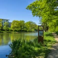
The route leads up to the ridge around Plittershagen, one of the oldest settlements in Siegerland. It passes through extensive forests and offers views as far as Oberberg region and the Westerwald. Part of the route follows the Hileweg, an ancient trade route. Past a witch dancing place it goes "ronner" into the agriculturally shaped but still idyllic Stöcker valley. After the Hasenweg, you reach Plittershagen, which was first documented in the 11th century, via a serpentine path. At the former bathing pond an old quarry gives insight into the geological history before returning to the starting point at the Friedenshort hiking car park.
Good to know
Best to visit
Directions
From the car park, go a bit into the forest, then a F5 sign leads us left on a path up the hill "ronner". Then we follow the paved road to the right and cross the Plittersche. The stream is the namesake of the nature reserve between Asdorfer Weiher and the village Mausbach. We cross the K1, pass the glass recycling bins, and follow the forest path to the left up the hill. At the height we go straight through a young beech forest, after a right curve we see the village Oberstöcken in the valley on the left. We leave the large clear-cut area behind us and pass a large square, the old Mausbacher sports field. Then we turn left and can now see in the distance the wind turbines on the Westerwald near Gebhardshain. Past the elevated hunting seat it goes into the forest where shortly after we meet the border path. Here we turn left. At the next junction we turn left again and after a few meters reach on the right the Hileweg, an ancient trade route. When we leave the forest, a large meadow and pasture area lies before us. On this hilltop, witches and wizards were once said to have met with the devil for a dance – at least that's what the protocols of the witch trials in the neighbouring County of Wildenburg from the mid-17th century state. We go left along the hollow path "ronner" to Oberstöcken. On the left by the path a seating group under an old beech tree at the cemetery offers a place to rest. We continue along the paved road past the Stöcker pond to the Hofgut Stöcken. Here a modern organic farm with suckler cow husbandry has been established, selling its products on the internet. A path leads to the modern cattle stable opposite the residential house. We continue along the road up to the Stöcker heights, where we turn right at the seating group into the forest. On the forest path it goes "ropp" up to the Reckhahn and then "ronner" to the Truberg. We follow the paved road to the right only a short distance. On the left by the way is an old border stone, which has marked the border between the Principality of Nassau – Siegen (NS) and the County of Sayn – Altenkirchen (SA) since 1690. Today this is the border between North Rhine-Westphalia and Rhineland-Palatinate. We turn half-left onto the forest path and then soon left into Hasenweg, which we follow until a long right curve. Please watch the trail sign on the left; it leads us on a serpentine path "ronner" to the Plittershagen monument. Here we enjoy the wonderful view of the village street, with the old school and its bell tower built in 1898 in the background. From the monument, the path goes left along into the village. We follow the street "Löcherbacher Weg" to the right and turn left at the bus stop onto Plittershagener Straße. We follow this to the edge of the village and further through the valley of the Plittersche. After a few hundred meters, we turn right off the paved street. Left of the path lies the former Plittershagen bathing pond, where a bench offers another opportunity to rest. Continuing the path, an old quarry on the right gives an exciting view into the geological history. The rock face is nothing other than fossilised seabed; you can clearly see the sand shaped into waves by water millions of years ago. The path continues along the slope to the paved street, which we follow to the right. After a few meters we reach the car park again.
Tour information
Cultural Interesting
Loop Road
Stop at an Inn
Directions & Parking facilities
From the city centre, it is recommended to start at the end of Friedenshortstraße.
Hiking car park Friedenshort
The bus line L152 runs from Morer Platz to Lagemannstraße. From there it is not far to Friedenshortstraße and to the Friedenshort car park.
Additional information
About the history of Plittershagen: www.heimatverein-plittershagen.de
About the witch hunt: https://docplayer.org/31937103-Friesenhagen-der-hexenwahn-im-wildenburger-land.html
About the organic farm in Stöcken: www.hofgut-stoecken.de
Author
Pauline Coroly
Organization
Stadt Freudenberg
Author´s Tip / Recommendation of the author
The village bakery Kurth offers a Siegerländer black bread, which is still made according to old craftsmanship on a sourdough basis.
Nearby


