Kindelsberg path


- 4:45 h
- 13.08 km
- 332 m
- 332 m
- 317 m
- 608 m
- 291 m
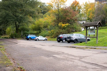
- Start: Parking lot below the Diakonie Klinikum Kredenbach in Kreuztal
- Destination: Parking lot below the Diakonie Klinikum Kredenbach in Kreuztal
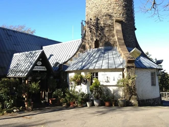
The path starts above Kredenbach via Bussardweg and leads us into the Loher Tal nature reserve. Passing the Loher Weiher, we hike through the Witschenberg quarry. It goes along a wall-like embankment to the Brüche Pit. On Hauberg paths, we reach the Brombach Forest Park via the Müsen Weidekampen. Through tall spruce stands (Feldmann's spruces) the path continues to the Wilder Mann mining area. On narrow paths, it goes through the Müsen cliffs (Pingenfeld Stahlberger Stock). Gaining elevation, we climb the Martinshardt. If the ridgeline path leading downhill gives us a small break, we then climb back up to the Kindelsberg parking lot. Only a short distance separates us from the staffed observation tower.'
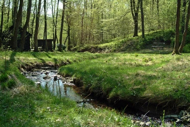
Well strengthened, we continue along a narrow path to the Waldesruh huts. Constantly descending into the valley, we witness the impressive Siegerland mining, from now on accompanied by the Strumpf, Glücksanfang, Jungermann, and Kuhlenberg pits. Passing the Zitzenbach natural swimming pool, we go through the valley back to the starting point.

Waypoints


Good to know
Best to visit
Directions
The path starts above Kredenbach via Bussardweg and leads us into the Loher Tal nature reserve. Passing the Loher Weiher, we hike through the Witschenberg quarry. It goes along a wall-like embankment to the Brüche Pit. On Hauberg paths, we reach the Brombach forest resting place via the Müsen Weidekampen. The path leads us through tall spruce stands (Feldmann's spruces) to the Wilder Mann mining area. Narrow paths take us through the Müsen cliffs (Pingenfeld Stahlberger Stock). Gaining further elevation, we climb the Martinshardt. If the ridgeline path leading downhill gives us a small break, we then climb back up to the Kindelsberg parking lot. Only a short distance separates us from the staffed observation tower. Well strengthened, we continue along the SGV forest damage path to the Waldesruh huts. Constantly descending into the valley, we become witnesses to the impressive Siegerland mining - from now on accompanied by the Strumpf, Glücksanfang, Jungermann, and Kuhlenberg pits. At the Martinshütte we find the dilapidated tunnel portal of the Friedrichshoffnung pit. A narrow path leads down through the Zitzenbach valley along the natural swimming pool and back to the starting point.
Tour information
Cultural Interesting
Loop Road
Stop at an Inn
Summit
Equipment
The circular route requires some sure-footedness; good footwear is recommended. At the halfway point there is a refreshment option at the Kindelsberg rest stop.
Directions & Parking facilities
Additional information
Kreuztal theme trails
- Hauberg trail in the Historical Hauberg Fellinghausen
- Nature experience trail Grubengelände Littfeld
- Kindelsberg path
- ROTHAARSTEIG access trail
- Buschhüttener Eisenhammer trail
- Reckhammer Auenweg in Littfeld
- Spring trail Osthelden
Six SGV sections maintain the approximately 275 km long hiking trail network in Kreuztal: the sections Littfeld, Krombach, Fellinghausen, Ferndorf-Kreuztal, Kredenbach, and Buschhütten. Guided hikes take place regularly, where guests are warmly welcome.
Contact person
City Kreuztal Tourism
Siegener Str. 3 / 57223 Kreuztal
Tel.: 02732/5 14 35 / Fax: 27 91 02 70
Email: stadt_kreuztal@kreuztal.de and m_haeusig@kreuztal.de
Literature
Author
Michael Häusig
Organization
Touristikverband Siegen-Wittgenstein e.V.
License (master data)

Author´s Tip / Recommendation of the author
At the Martinshardt, enter the summit book under the summit cross.
Rest at the shelter "Sonnenberger Rotsche" with snack island and view of Kindelsberg.
Safety guidelines
Sure-footedness is required for the "rock variant"
Map
Hiking map Kreuztal, available in regional bookstores and at the city of Kreuztal, €5.00
Bike touring and leisure map Siegerland-Wittgenstein with companion booklet, 1:50,000, ISBN 3-87073-280-3, €7.95
Nearby


Download GPX file