Rothaarsteig Trace - Zinser Border Path


- 3:45 h
- 14.44 km
- 246 m
- 250 m
- 456 m
- 667 m
- 211 m
- Start: Hiking car park 'Am Zinsebach'
- Destination: Hiking car park 'Am Zinsebach'
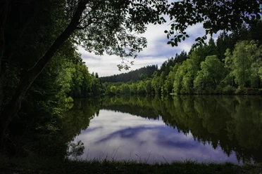
Starting in the picturesque small village of Zinse, the 14 km long circular route follows the meandering Zinsebach, along the Rösper Pond and past the enchanted ponds of the Schwarzbach valley. Many rare plant and animal species such as kingfisher, grey wagtail, and greylag goose can be observed here. From there, the path leads steeply uphill directly along the border to Heinsberg to the Hermeskopf (611 m). Through idyllic beech forests and over narrow paths, you can also count the border stones along the way, which commemorate the old border between Wittgenstein and the Electorate of Cologne Sauerland.
With a detour over the Dreiherrenstein (673 m) – where the territories of the Electorate of Cologne Duchy of Westphalia, the County of Nassau-Oranien, and the Princes of Wittgenstein-Hohenstein met – the path finally leads back along the lonely Zinsebach valley with the small rock cave, the former settlement of Fuchshausen, back to Zinse.
Waypoints


Good to know
Best to visit
Directions
The Zinser Border Path connects water and nature highlights and offers us a border experience that dates back to the 17th century.
Starting in the picturesque small village of Zinse, the 14 km long circular route follows the meandering Zinsebach, along the Rösper Pond and past the enchanted ponds of the Schwarzbach valley. Many rare plant and animal species such as kingfisher, grey wagtail, and greylag goose can be observed here. From there, the path leads steeply uphill directly along the border to Heinsberg to the Hermeskopf (611 m). Through idyllic beech forests and over narrow paths, you can also count the border stones along the way, which commemorate the old border between Wittgenstein and the Electorate of Cologne Sauerland.
With a detour over the Dreiherrenstein (673 m) – where the territories of the Electorate of Cologne Duchy of Westphalia, the County of Nassau-Oranien, and the Princes of Wittgenstein-Hohenstein met – the path finally leads back along the lonely Zinsebach valley with the small rock cave, the former settlement of Fuchshausen, back to Zinse.
Tour information
Cultural Interesting
Loop Road
Equipment
The Rothaarsteig runs over numerous natural paths away from agricultural and forestry roads. Therefore, weatherproof clothing and sturdy footwear are a must for every hike. We want you not only to experience the 'Path of the Senses' and the Rothaarsteig traces "dry" but also "on good feet".
In our small hiking shop at rothaarsteig.de/shop you will also find a selection of Rothaarsteig items to prepare for your route or as souvenirs. We are also happy to recommend the durable and high-quality outdoor equipment from our long-standing partner, the outdoor outfitter Tatonka.
Hiking backpack
With a suitable hiking backpack your tour on the Rothaarsteig is twice as much fun! Hiking backpacks offer very comfortable carrying properties thanks to a ventilated carrying system, which ensures that sweat evaporates immediately. They can be fixed with a belly or hip belt and thus sit firmly on the back with every movement. In addition, they are equipped with a practical holder for trekking poles and often offer a compartment with a hose outlet for a hydration bladder, so that fluid supply is always ensured. Here you will find hiking backpacks from the outdoor outfitter Tatonka in various sizes for day hikes and multi-day tours and with different ventilated back systems.
Rainwear
If variable weather is forecast for your tour on the Rothaarsteig, remember to pack a lightweight rain jacket or rain poncho. They take up almost no space in your backpack and also keep unpleasant wind away. Also practical are gaiters that protect the trouser legs from dirt and moisture. With our partner, the outdoor outfitter Tatonka, you will find high-quality, breathable rain jackets with minimal pack size, lightweight rain capes, and gaiters for the trouser legs to keep them protected from dirt and moisture.
Here you will find the Tatonka rain jackets for women
Here you will find the Tatonka rain jackets for men
First Aid Kit
So that you can fully enjoy your hiking tour on the Rothaarsteig, a first aid kit should definitely be in your backpack. After all, nothing is more annoying than a blister on your foot or minor injuries that cannot be immediately treated cleanly.
The first aid kits from the outdoor outfitter Tatonka are filled with all the essential materials for the initial treatment of injuries and also include an "outdoor cheat sheet" with concise and clear guidelines for correct behavior in case of emergencies in the open nature.
Here you will find the first aid kits from Tatonka!
Food and drinks
On some stages, especially between Lahnhof and Dillenburg, there are unfortunately no places to eat along the way. Remember to pack especially food and drinks here. Adequate drinks are particularly important in summer.
Directions & Parking facilities
Additional information
Dining options in Erndtebrück:
Further information about the Rothaarsteig is available at www.rothaarsteig.de as well as by phone at the free service hotline +49 2974 / 499 4163. We are happy to advise you on your personal route planning.
Author
Nathalie Treude
Organization
Touristikverband Siegen-Wittgenstein e.V.
License (master data)

Author´s Tip / Recommendation of the author
- Keep your eyes open at the roadside: besides border stones that invite counting, tasty blueberries shine in juicy blue in July/August.
Safety guidelines
Information about the emergency signs on the Rothaarsteig
Hiking trails mostly run away from towns and settlements, and all hikers have at some point wondered what would happen if an emergency occurs. How can I be found here? Where exactly am I? Can the rescue service reach me?
In an emergency, it must be quick! Therefore, the Rothaarsteig is continuously equipped with so-called emergency signs. On the green-white plaques attached to the posts of the signposts there is a number you must give when making your emergency call. This way the rescue team knows exactly where you are, saving valuable time.
Note on the increased risk of forest fire
Please note that due to dryness there is currently an increased risk of forest fire! Please observe the following instructions:
- Observe the legal smoking ban in the forest - it applies in spring, summer, and autumn, specifically: from March 1st to October 31st.
- Observe the ban on open fires in the forest and within 100 meters of the forest.
- Take glass out of the forest – the burning glass effect can cause forest fires.
If it is (too) late:
- Extinguish small ignition fires if it is safe for you to do so. Check the spot carefully if necessary.
- Report fires via "112".
- Leave the danger area by the shortest route.
The forest thanks you!
Bison and wildlife on the Rothaarsteig – behavior tips
Many wildlife species live in the forests along the Rothaarsteig. Encounters with red deer, wild boar, mouflon, and for some time also bison are possible. The latter may be encountered on the Rothaarsteig between Albrechtsplatz and Dreiherrenstein.
The risks posed by bison to hikers are low and can be minimized to an absolute minimum by appropriate, respectful behavior.
- Walk calmly and inconspicuously at a distance past the animals, do not startle them and do not look them directly in the eyes.
- If the animals approach you, stay calm, do not turn your back to them, and leave the area without haste, but always with sight of the animal.
- If the animals come closer than a distance that makes you uncomfortable, call out loudly, whistle, or make yourself acoustically noticeable in another way. Watch for threatening gestures!
- If boars "chatter their teeth" or bison lower their heads, they expect you to withdraw. Step back!
- If you have a dog with you, keep it under control on a leash. If an animal attacks your dog, leash it! The dog is faster and more agile than you and will definitely find you again!
Map
In our brochure “Rothaarsteig Traces – All Circular Hiking Paths at a Glance” you will find map excerpts and brief explanations for all 13 circular hiking routes, including a map of the Zinser Border Path. Also shown here are the other 13 Rothaarsteig traces with maps, short explanations, and the most beautiful rest areas along the route. You can conveniently and free of charge order the booklet to your home or view it online as a PDF or flip catalog at rothaarsteig.de/prospekte.
We also recommend our Rothaarsteig Traces Hiking Pass. Those who have hiked 8 of the total 13 traces receive a hiking certificate and a Rothaarsteig pin and participate in our annual raffle. You can also easily order the hiking pass free of charge to your home or download it directly online at rothaarsteig.de/prospekte.
The original Rothaarsteig hiking map at a 1:50,000 scale on waterproof paper, with current trail guidance and useful markings such as shelters, parking lots, bus stops and much more, can be ordered shipping free for 11.00 euros at rothaarsteig.de/shop and delivered comfortably to your home.
Nearby


Download GPX file