Rotmilan Höhenweg - Relaxing border experience


- 12:30 h
- 45.19 km
- 915 m
- 920 m
- 377 m
- 671 m
- 294 m
- Start: Elsoff, village square or Christianseck, Struthbach parking lot
- Destination: Elsoff, village square
The cross-border circular hiking trail through the Elsoff valley is just under 44 km long.
The pentagonal trail sign leads through the Wittgenstein villages of Elsoff, Christianseck, Diedenshausen, and Alertshausen as well as the Hessian village of Neuludwigsdorf.
Over everything that connects the two federal states soars the red kite, bird of the year 2002.
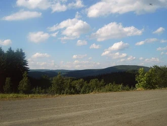
The circular trail, at altitudes between 380 and 675 meters, offers rich nature with magnificent views over the Wittgenstein land and the Eder mountain region. There is plenty of variety on this route and different ways to take it.
Not only demanding hikers come to their own here, but also cyclists. Sections over the heights are especially suitable for families with prams and people dependent on wheelchairs or walkers.
Also, ten feeder paths are marked, which can be used for tours of different lengths. Experience an interesting "border experience" with impressive panoramic views!

Waypoints


Good to know
Best to visit
Directions
We begin our hike at the Elsoff village square, the path leads us to the town exit. There, a steep ascent follows to the Delle shelter, which offers us a beautiful view of the Elsoff valley.
Through dense spruce forests, we reach the Hermannstein, at 610 meters the highest elevation in the Garsbach valley. We arrive at Hof Teiche and see the village of Christianseck. Due to the scenic beauty of the place, Christianseck is also called the Wittgenstein Switzerland.
We head westward to Schüllar, from Hof Burg we walk past Kyrill areas and come to the district road, which leads further to Wunderthäuser Sohl. Over the Jochumskopf, it goes to the highest point of Siegen-Wittgenstein, the 789 m high Gorges.
We finally reach the Pastorenwiese ski hut, where we can branch off to the history and culture trail of Wunderthausen. Over the Haiskopf, it goes past the wind turbines on Hessian territory to the Heiligenholz.
After crossing the forest, we gain a view over the beautiful Elsoff valley. In several bends, it gently descends into the Inselbach valley. The path leads us past farms in idyllic isolated locations. Again and again, wonderful views open up to the Wittgenstein mountain land.
After about 10 kilometers, we reach the Federal Silver Village Elsoff again. Over a meadow path, the route leads into the beautiful half-timbered village.
Tour information
Loop Road
Suitable for Pushchair
Equipment
Hikers are recommended to wear sturdy footwear and bring packed meals.
A starting point is at the Elsoff village square, an alternative is the Struthbach parking lot in Christianseck.
Directions & Parking facilities
From Bad Berleburg, you reach Elsoff via the L717 towards Diedenshausen – stay right behind the Laibach guesthouse restaurant towards Christianseck/Elsoff.
(You can also start the route from the Laibach guesthouse restaurant and Christianseck).
Or drive from Bad Berleburg via the B480 towards Raumland. In Raumland, keep left and follow the L553 towards Dotzlar/Schwarzenau. Behind Schwarzenau, follow the signs and turn left onto the L902 towards Elsoff.
You can also start the route in the following other Wittgenstein villages:
- Diedenshausen,
- Christianseck,
- Alertshausen
As well as from Neuludwigsdorf (Bromskirchen) on the Hessian side.
You can reach the village of Elsoff from Bad Berleburg by bus line R33.
More information at www.zws-online.de
Additional information
The Rotmilan Höhenweg is characterized above all by its flexibility. This route offers both challenging sections as well as long paved stretches. Whether active hikers, cyclists, walkers, or people with limited mobility – the path is suitable for everyone.
Contact and further information:
Rotmilan Höhenweg Association (VRMHW)
Phone (0 27 50) 606
Author
BLB-Tourismus GmbH
Organization
BLB-Tourismus GmbH
License (master data)

Author´s Tip / Recommendation of the author
Nearby


Download GPX file