Via Celtica - Ticking like the Celts


- 6:00 h
- 14.03 km
- 600 m
- 600 m
- 383 m
- 557 m
- 174 m
- Start: Car park "Laubrother Straße" (Cultural center) Dotzlar
- Destination: Car park "Laubrother Straße" (Cultural center) Dotzlar
The "Via Celtica" is a spiritual hiking trail. Spirituality is now at the center of society. Many people seek orientation, retreats, and meaning in the modern world. In simplified terms, spirituality stands for the search for meaning.
15 kilometers long and fairly demanding - this is what the "Via Celtica" offers. In combination with the "Wittgensteiner Schieferpfad", the "Via Adrina", the route "Bei de Hullerkeppe" and the long-distance path "Ederhöhenpfad", a high-quality and dense network of paths results. You therefore have considerable freedom to design your hike individually. For example, you can modify, shorten, or extend your started route on the way – from a three-kilometer section to marathon distance.
Impressive natural phenomena such as a colorful flower meadow, a babbling spring, the lively Eder, majestic trees, mystical forests, and rock landscapes with towering cliffs line the demanding route as anchor points. How many anchor points you visit during a route is entirely up to your own wishes and requirements.
An extended version with interesting aspects and exciting backgrounds can be found under "Details".


Waypoints


Good to know
Best to visit
Directions
The route starts in Dotzlar and leads you to a flower meadow. The meadows must have looked like this or something similar in Celtic times. The economy back then was based on agriculture and animal husbandry. You now walk uphill to the Meisbach spring. The veneration of springs was once widespread all over the world.
After a short distance, you will see the Burgberg on the opposite side, a regular, aesthetically "beautiful" mountain. At the height, you reach the nature reserve "Großer Keller". Striking are the mighty spruces with at least two crowns, the "Zwiesel". The juniper heath next door is under strict nature conservation. Juniper was an important medicinal plant for the Celts. From a viewing platform, you enjoy a wide view into the Eder valley and the surrounding mountain landscape.
It goes downhill and you reach the Eder below the bridge. Rivers were symbols of the cycle of life for the Celts. After a strong climb, you enter a mystical oak forest of the Honert, interspersed with numerous rock cliffs. After another descent, you reach a highlight of the route at the Dotzlar weir. Here, three natural phenomena that were of great importance to the Celts come together: a river, a rock ledge, and an ancient oak tree.
After a short, strong climb, you approach the next viewpoint. You recognize the distinctive pyramid-like Hoher Stift, over which the sun rises on the day of the winter solstice and to the left of the Honert the Rammelsberg, over which the sun appears on the day of the summer solstice. You hike to the next place of power, another rock region with vertical cliffs and extensive rock debris slopes.
After another ascent, you reach a landmark of Dotzlar, the "Zollbaum", and an area where juniper was planted as part of a nature conservation project. The destination of the hike is the Celtic-age castle, whose remains are barely discernible. The castle is a mysterious and enigmatic place. It is still only conjectured what function the site had. The hike ends. You overlook two-thirds of the landscape you have walked through. Visible are the area of the Meisbach spring, the grounds of the nature reserve, the Eder valley, and the Honert. After a short downhill section, you reach the starting point again.
Tour information
Cultural Interesting
Loop Road
Stop at an Inn
Equipment
The route is 14.5 kilometers long, the duration is about five to six hours. The path is quite demanding due to steep sections and many trails. The basic requirements are good fitness, sturdy footwear, and surefootedness.
Backpack provisions and sufficient water are recommended.
Directions & Parking facilities
By car, you reach Dotzlar from the A45 Dortmund-Frankfurt motorway, Siegen exit, then continue via federal roads B62 and B480.
The "Laubrother Straße" parking lot is located in the center of Dotzlar. Coming from Raumland, turn left towards the cultural center in Dotzlar. After about 400 m, the parking lot is on the right side.
Take the German railway via Siegen to Bad Berleburg station, then a bus transfer towards Dotzlar is necessary.
Take bus line R33 towards Hatzfeld and get off at the stop "Dotzlar - Junction Sassenhausen". The "Laubrother Straße" car park is located in the center of Dotzlar and is the start and end of the hiking trail.
https://www.vws-siegen.de/pdf/R33.pdf
Additional information
Several hiking routes in the premium hiking destination Bad Berleburg lead through the middle Eder valley: An attractive river, other small waters, a breakthrough valley, steep slopes, rock scenes, primeval forest sections and manifold views characterize the landscape.
Bad Berleburg looks back on a long tradition in "quality tourism on hiking trails". The Wittgensteiner Schieferpfad, a school project, was the first planned premium trail in Europe. Lateral thinking was required, student ideas stirred up the dusty hiking world. A multitude of cooperation partners as well as nationwide, interdisciplinary, and demanding competitions brought momentum to the project.
Currently, we are striving again in Bad Berleburg to set a strong impulse for innovation. And here too, we look beyond the horizon again. In addition to the known preferences of hikers, we embrace social trends on the "Via Celtica" trail. Three terms stand out: Celts, spirituality, and laboratory path.
Freely following the book "Vom Verschwinden der Arten" by Katrin Böhning-Gaese: We all depend on nature, its wealth and services. We need water, air, food, and recreation. Strictly speaking, we are part of it.
In fact, we humans overuse nature at a breathtaking pace. Unique habitats for fauna and flora, natural filters for water and air, and storage for CO2 are lost. The term biodiversity must become a topic of conversation just like climate change, the energy crisis, pandemics, the pension system, or the education of our children. To get at the center of political debate, public pressure is also needed. Accordingly, overarching objectives present themselves for the "Via Celtica".
The project aims to:
- Create knowledge and contribute to social change
- Tell stories that interest people (storytelling)
- Include people
- Seek broad participation in society
- Start participation projects based on citizen science
The great goal of the premium trails in Bad Berleburg is to strengthen nature connectedness. In the past, it was believed that purely through knowledge transfer, the environmental behavior of people would change positively. This has proven to be an illusion. Rather, environmental psychological factors are decisive. The quality of nature experiences, active perception, and connection with positive feelings are in the foreground. The basis for this is highly attractive and close-to-nature routes.
The Wetterau counts as the core area of the virulent Celtic culture. It had a strong influence on the surroundings. Whether Wittgenstein belonged to the periphery of the culture is disputed. The related discussion is exciting but not the actual topic of the path. The so-called red thread is the human-nature relationship using the example of the Celts. What was sacred to the Celts also magically attracts modern man. The Celts are a mysterious and enigmatic people – the topic itself is immensely fascinating. In addition to the historical perspective, global references to other countries, worldviews and religions are made.
Spirituality has now reached the center of our society and is an important trend. For many people, much has gone awry today. Stress and hustle dominate everyday life. Modern man seeks balance and retreats. He finds these above all in nature. The new where to is the why. Simplified, spirituality equals the search for meaning. What gives me support and orientation?
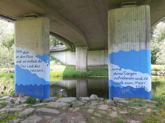
The "Via Celtica" is both a hiking trail and a laboratory path – the concept thrives on participation. First steps in this regard have been implemented. Citizens systematically sought inspiring places, landowners provided private property for cross-section routes, volunteers built long paths with hoes, shovels and pruning shears. Furthermore, a flower meadow has been created, juniper planted, and a spiritual saying artistically designed.
The intense appeal of the hiker on exceptional natural places and enigmatic cultural sites causes him to become aware of the richness of the landscape. Purposefully, the hiker develops ideas for the further development of the project. In other words: We explore our landscape together with locals and guests, design participatory ideas for sustainable development and implement these thoughts.
A digital interaction platform is planned: People mainly tell their stories with audio and video contributions, photos and texts at the anchor points. Above all is the message: A contemporary "back to nature" is of existential importance. Technology can help with this. Nature and technology thus harmonize. The hiking trail is a stage and the audience is the focus. Current social demands and discourses find their place.
In the context of the path's opening, radio produced three demanding contributions, television a short broadcast, and opponents of the naming and concept articulated their criticism in lectures and newspaper reports. Even if the topic "Celts in Wittgenstein" is secondary, the discourse needs to be further developed.
Basically, there are certainly different views within the archaeological discipline. Renowned scientists classify Wittgenstein as periphery and thus part of the Celtic cultural area. The LWL archaeology also confirms a highly developed mining landscape in Siegerland operated by immigrant specialists from the Celtic area. For South Westphalia overall, it is assumed that not only goods were imported into the region, but also beliefs. Ritual similarities with the Celtic world include, for example, depositional customs, a weapons depot on the Wilzenberg near Schmallenberg, a depot of agricultural tools on the Kahle near Lennestadt. LWL archaeologists also discovered a weapons depot at Burg Aue in Wittgenstein. Interestingly, the context to the Celtic world has not (yet) been established in this case – neither in written nor oral presentations.
The necropolis Birkefehl near Erndtebrück dates back to the Hallstatt period. Among the finds were torc necklaces, presumably belonging to an upper class. This upper class probably organized the construction of early castles in the region. Thus, the influence of the Hunsrück-Eifel culture, which in turn had close contacts to the southern German Celtic Hallstatt culture, is tangible. This sums up the presentations – also of the LWL archaeology. Religion and social structure in the South Westphalia region were strongly influenced. Celtic culture had a strong impact. The presence of the LWL archaeology in this context is debatable.
How can statements and style be reconciled with the Faro Convention, the citizen science model, and the principles of cultural pedagogy?
The Faro Convention, adopted in 2005 by the Council of Europe (not yet ratified in Germany), considers participation in the research of cultural heritage a citizen's right. Particularly Article 4a clearly states that everyone has the right to contribute to the enrichment of cultural heritage. Moreover, everyone has the right to be involved in archaeology, which is part of cultural heritage, and to contribute to its research and interpretation. Overall, the approach goes far beyond the archaeological perspective.
An example illustrates the need for different perspectives. Wencke Elbert submitted the dissertation "The Architecture of the Celts – Settlement patterns, building forms, and construction principles of the Iron Age" in 2018. The intention of her work is to stimulate viewing the surviving remains of prehistoric and early historic buildings through different "glasses" and thus various perspectives. She addresses the manifold interpretative problems that a hitherto purely source-oriented study of social and settlement structures involves. In this context, she also complains that the discussion of the connections between cultural contacts and architectural innovation – also in connection with architectural sociological considerations – has only been conducted on an interdisciplinary level in rudiments so far.
The basis of the Via Celtica project is the scientific method of nature and cultural interpretation (heritage interpretation), linked with education for sustainable development.
The goal is to win people over to build a close relationship with their natural and cultural heritage and to appreciate it. Prerequisites are appropriate phenomena with high interpretive potential, those that arouse curiosity, carry secrets, prompt reflection, and can be placed in a larger context. Decisive for this is a red thread or guiding idea. In Via Celtica, this primarily concerns the understanding of nature of current indigenous peoples and historical cultures, especially the Celts.
The guiding idea must touch the visitor or hiker. Not experts, but those seeking recreation are addressed. For them, the phenomenon must have significance. A purely thematic approach with a bundle of factual information is therefore out of place.
The method has the following quality features:
- Participation, questioning one's own attitudes (reflection)
- Consideration of different perspectives (interdisciplinarity)
- Reference to the individual's life world
Suitable key phenomena have the quality to serve as windows to the world, as interfaces that allow larger contexts to be shown and developments to be contemplated at certain places. The Via Celtica especially appeals to people who want to knock down entrenched structures in their minds, combined with a longing for self-experience. They want to find new perspectives and open up new horizons.
Author
BLB-Tourismus GmbH
Organization
BLB-Tourismus GmbH
License (master data)

Author´s Tip / Recommendation of the author
Cold drinks are available en route from the earth refrigerator.
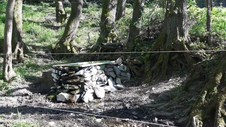
Two forest rest stations invite you to a special stop in nature.
Map
Wittgenstein hiking map: Bad Berleburg with the northern part of Erndtebrück and Bad Laasphe with the southern part of Erndtebrück €10.00
ISBN 978-3-86636-940-5
Nearby


Download GPX file